 | The Xenophile Historian |

 |
 |
 |
 |
 |
 |
 |
 |
 |
 |
 |
 |
 |
 |
 |
 |
 |
 |
 |
 |
 |
 |
 |
 |
 |
 |
 |
 |
 |
 |
 |
 |
 |
 |
A History of Latin America and the Caribbean
Chapter 1: Ancient America, Part I
Before 1492
This chapter is divided into three parts, which cover the following topics:
Part I
Part II
| The Moche: Masters of Clay | |
| The Nazca: Lines In the Desert | |
| The Magnificent Maya: The Early Classic Era | |
| The Magnificent Maya: The Late Classic Era | |
| The Collapse of the Teotihuacan and Maya Civilizations | |
| Tribes of the Caribbean | |
| The People of El Dorado | |
| Tiahuanaco, the City of the Altiplano | |
| The Huari Empire |
Part III
| The Toltec Middlemen | |
| Yucatan: The Maya Epilogue | |
| The Mixtecs | |
| Forerunners of the Incas | |
| The Tepanecs and the Rise of the Aztecs | |
| The Bloody Splendor of the Aztecs | |
| The Inca Conquests | |
| Tahuantinsuyu | |
| On the Threshold |
Introduction
Greetings. From 2006 to 2010 I wrote a series of history papers on the United States and Canada, called The Anglo-American Adventure. Although I feel I did a thorough job covering those two nations, in terms of land area and population they only make up one third of the western hemisphere. Now with this series I plan to figuratively “drop the other shoe,” and cover the remaining two-thirds.
The area covered here will be all of the mainland south of the Rio Grande River: Mexico, the seven countries of Central America, and the whole continent of South America(1). It will also include the islands in and near the Caribbean Sea, from Bermuda to Trinidad. As a US citizen, I must confess that we don't pay as much attention to the Latin American and Caribbean nations as we should, for the same reason that we don't give much attention to Canada; these nations have been in the US “backyard” or sphere of influence for as long as anyone living can remember, and are thus taken for granted. Likewise, world history books tend to neglect Latin America history; they will briefly mention the pre-Columbian civilizations, and talk a little about individuals like Cortez, Pizarro, and Bol�var, but that's it. Hopefully these papers will help in filling that void; elsewhere I have called myself an “Historian of the Obscure,” filling in the gaps that other historians leave behind them.
A few unique features about Latin America need to be mentioned before we begin the narrative.
Numero Uno: The main name of this region. The term “Latin America” was coined by Europeans in the nineteenth century, to promote the idea that the Spanish and Portuguese-speaking nations of the New World have more in common with the European nations that speak Romance languages (e.g., France, Spain, Portugal and Italy) than with the mostly Teutonic populations of the United States and Canada. The term stuck because it is true, but we shouldn't forget that Belize, Guyana, Suriname and most Caribbean islands have English and Dutch-speaking residents--they would qualify as “Teutonic,” too.
Numero Dos: The second is along the line of the first. In recent years, the terms “Hispanic” and “Latino” have appeared to describe those of Spanish and Portuguese heritage; the chief characteristics are a Spanish/Portuguese name, and the fact that most people of that heritage belong to the Roman Catholic Church. However, people often use the terms as if they define a separate race from whites, blacks and Asians, so keep in mind that a Hispanic/Latino person belongs to a particular culture, but does not have a certain “look” or skin color. Both whites and blacks can be considered “Hispanic”; so can Native American tribes like the Maya and Quechua. Sometimes even Filipinos are classified as Hispanic; they are Asian, of course, but because Spain ruled the Philippines for more than three hundred years, they are also part Spanish in ancestry, have Spanish-sounding names, and are 85% Catholic.
Numero Tres: The pre-Columbian aspect of Latin America's heritage is a rediscovered part of world history. The Maya, Aztec and Inca civilizations were certainly grand in their heyday, but they and the lesser tribes around them had their cultures almost entirely obliterated by the Spanish conquests of the sixteenth century. After the conquistadors were finished, few people even knew what America had achieved before the Europeans arrived; most books simply started the history of the Americas with Christopher Columbus. Thus, when explorers and archaeologists began uncovering lost cities like TIkal and Machu Picchu, their discoveries came as a big surprise to the world. As with the excavations conducted in the Middle East since 1800, this has restored an important legacy to all of humanity. Putting together the pieces has been difficult, though, because (1.) only the civilizations of Mesoamerica could read and write, (2.) only the countries known to contain buried treasure (e.g., Mexico, Guatemala, Colombia and Peru) saw much excavation until recently, and (3.) because robbers (huaqueros in Peru) have plundered valuable objects from archaeological sites, often smuggling them abroad, before scientists get a chance to study them. Therefore the story we tell before 1492 will have to be an incomplete story, with the very real possibility that new pieces will be added later, forcing a rewrite of this chapter, at least.
One response to the rediscovery of pre-Columbian America has been the theories of diffusionists, who assert that ancient Americans could not have done it all by themselves; Egyptians, Phoenicians, Celts, Chinese, black Africans, Vikings, or somebody else from the Old World must have crossed the oceans to teach the elements of civilization.(2) However, most of these theories fall flat, due to faked evidence (e.g., the “Vinland Map”) or chronological problems. To give one example of the latter, the pyramids of the New World look like the step pyramids Egypt built around 2500 B.C., but most New World pyramids were built after 1 A.D.(3) To the author, the most credible evidence of trans-oceanic crossings before Columbus is L'Anse aux Meadows, a thousand-year-old settlement in Newfoundland that was probably built by the Vikings. For the other cases, it is best to assume for the time being that ancient Americans were the only ones responsible.
Numero Cuatro: After independence came, Latin America was far less successful than Anglo-America, though some countries (e.g., Brazil) are blessed with many natural resources. Everywhere they have had a hard time establishing governments that manage their resources and people fairly and efficiently; the story of Latin America since 1810 is a long series of juntas, dictatorships and coups where the names change, but the plot generally remains the same. When civilian governments fail, the military often takes over, hopefully to clean out corrupt institutions so that civilian rule can return, but all too many times the generals have refused to step down, and they become part of the problem, rather than part of the solution. One reason for this vicious circle is that Latin Americans, unlike the ex-citizens of England who founded the United States, did not gain political experience before independence, so they did not have precedents like the Magna Carta to instruct them. The other reason is that Latin American societies tend to be socially unequal; most of the power and wealth is concentrated in the hands of a few, and there isn't a system of checks and balances to make leaders look out for the interests of those outside their social caste.
Numero Cinco: To understand Latin America today, you have to understand the antipathy many Latin Americans have for their big northern neighbor. All countries south of the United States have lived in its shadow, and have played the role of satellite states for at least part of the last two centuries. There is also quite a bit of bad feeling over the times when the US intervened militarily, like the 1980s invasions of Grenada and Panama. Of course, some have argued that they needed the help of a friendly superpower to fix their economic and political problems, and their answer is that like people everywhere, they would rather have a bad government they can call their own, than a good government imposed on them by somebody else. There were also several cases in the past when a dictatorship sought US aid, and the Yankees gave it with no questions asked. Many of those dictators were conservative politically, so when they fell from power, their successors were often both anti-American and followers of a leftist ideology (e.g., Batista vs. Castro in Cuba). Will the day ever come when these nations act independently, rather than follow Uncle Sam's lead? Perhaps after you've read this narrative you'll be able to answer that question for yourself.

This “Yankee Go Home” graffiti was seen in 2010 on a street in Caracas.
I've talked enough for an introduction, so now, on with the story!
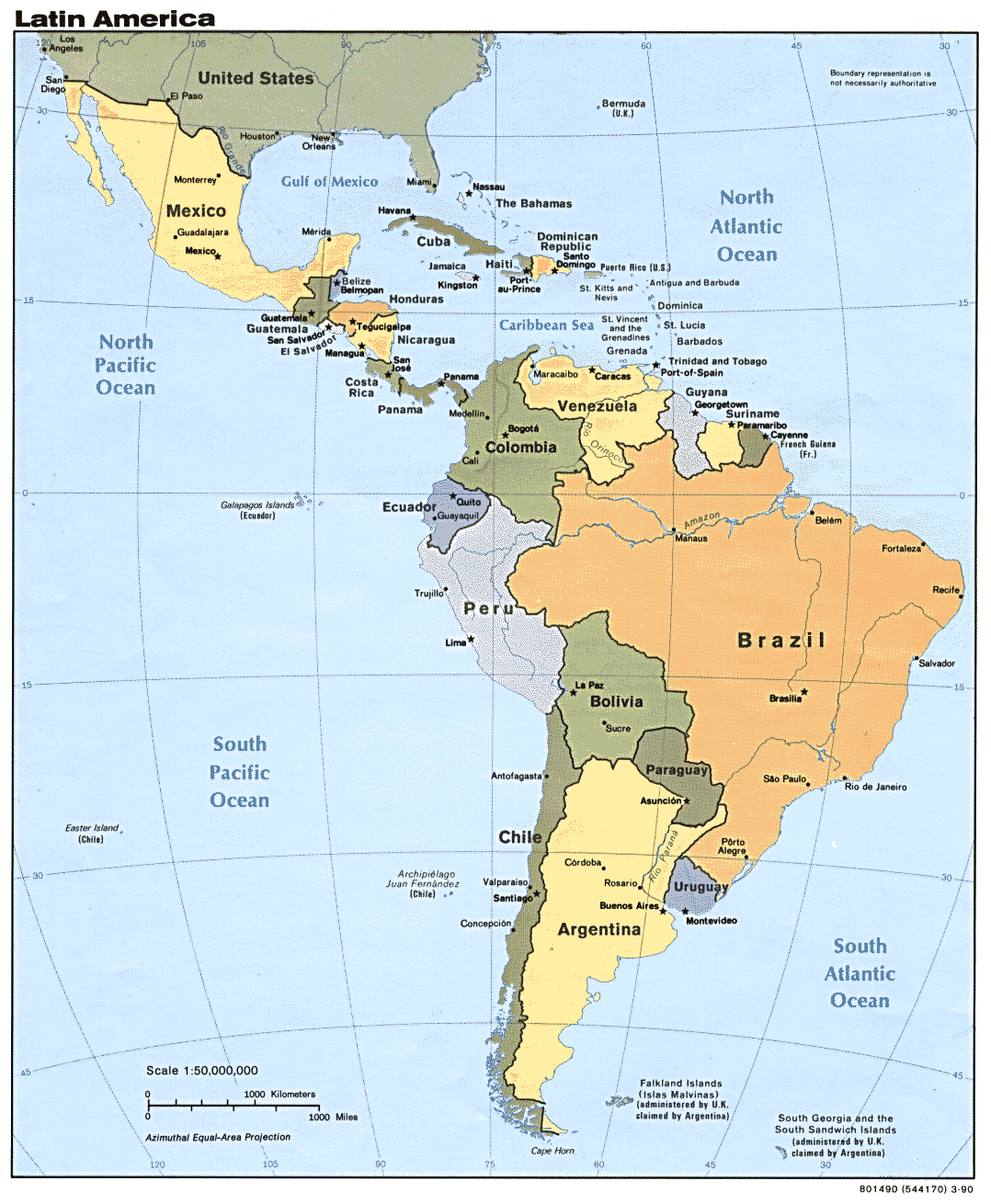
The Nations of Latin America.
The First Americans
If you have read any of my other works, you know I like to go way back as far as possible, to start a story from the very beginning. In my North American history series, for instance, I began with the ice age, not with Columbus. For this series, we can start at the same point, when the first people to settle the Americas came over from Asia. Or should I say, we believe they came over from Asia; we don't know exactly where they were previously, nor do we know the route they took from the eastern to the western hemisphere. After all, when you've lived in the same place for thousands of years without knowing how to write, as the first Americans did, you tend to forget that your people ever lived anywhere else. I recommend reading this section for the theories on where they came from and how they arrived. Of the three or four groups that crossed over from the Old World, it looks like only the first group made it to Latin America; the ancestors of the Na-Dene/Athabascan tribes and the Eskimos/Inuit went no farther than the lands that would some day become the United States and Canada.
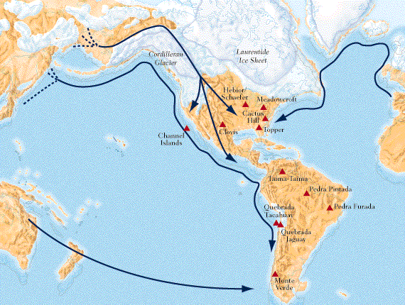
An ice age map showing the proposed migrations from the Old World to the New World. The conventional theory is that the first Americans marched across Beringia, a land bridge between Siberia and Alaska that no longer exists, and then crossed the icy area between the Cordilleran Glacier and the Laurentide Ice Sheet to reach more pleasant parts of the hemisphere. However, the author thinks a sea route, following the Pacific Rim from Northeast Asia to the Americas, would have been easier. The arrows coming from Europe and Australia suggest alternate routes, because a few paleo-Indian skulls have been found that look more European or Australoid than Asiatic. Important prehistoric campsites are marked with red triangles.
How America's first inhabitants arrived is not the only question we have about them. Paleontologists have not yet conducted enough excavations to determine when they crossed over, or where they first settled down. One paradox, for instance, is that the oldest campsites found so far are in South America, not close to the glaciers in North America. Currently most textbooks assert that people may have come over from the Old World as early as 50,000 years ago, and that it may have taken as many as ten thousand years to populate the entire Americas. I'm skeptical of such dates myself, due to the number of known errors radioactive dating has produced, but we have to admit that members of the human race have lived in the western hemisphere for a long time, to the point that some New World civilizations are old enough to rival those in the “Old World.”
However, they got here, the first Americans faced major challenges from a variety of climates, once they arrived in the temperate and tropical zones. In my North American history, I explained how that caused different native cultures to develop in forest, prairie, desert and coastal areas, to deal with the weather and make the most of available plants and animals. South of the Rio Grande, the climates encountered were arguably more extreme than those north of that river. These places included the pleasant tropical paradises of the Caribbean islands, the fearsome jungles of Central America and the Amazon basin, the towering peaks of the Andes, the Altiplano--the world's highest desert--on top of the Andes, and the hostile but spectacular scenery of Patagonia and Tierra del Fuego.(4) Nevertheless, once they arrived they spread quickly, and adapted to every new environment they discovered; we now estimate that they could have settled the entire western hemisphere, from Alaska to Patagonia, in less than a thousand years.
Unfortunately, residents of the New World were at a disadvantage in some critical areas. In his book Guns, Germs and Steel, Jared Diamond identified four things required for a civilization to succeed: a large population base, abundant farmland, many useful plants and animals, and easy access to other civilizations (to promote trade and an exchange of ideas). In all of those factors, the Old World had more than the New World.
First, the population of the tribe(s) who made the crossing was quite small, probably 70-300, a far smaller community than the ones they left behind in the Old World. Second, there were places for farming, but before the white man tamed the Great Plains of North America, and the savanna regions of Brazil and Argentina, the New World did not have a food-growing zone as extensive and productive as the Fertile Crescent, or the North China Plain. Third, when it came to useful plants(5), the New World was indeed greatly blessed, but this was offset by a shortage of useful animals; at the time the Europeans made contact, there was no New World equivalent of the horse, ox, donkey, camel or elephant.(6) New World civilizations never even learned how to use the wheel for transportation, though they sometimes made toys with wheels for their children. Finally, there has been at least intermittent contact between Old World civilizations for more than two thousand years, but in the New World, we have yet to find evidence that the pre-Columbian civilizations of Mesoamerica and South America even knew of each other's existence.
The main result of these limitations was that American civilizations progressed at a much slower rate than their European, Asian and African counterparts. No tribe learned how to forge iron, and only those in the two main civilized areas worked much with metals at all. The form of writing developed in Mesoamerica resembles Egyptian hieroglyphics, but nobody in pre-Columbian America ever invented an alphabet; in fact, the tribes outside of Mesoamerica were always illiterate.(7) And it was not just technological progress that was slow; social and political progress moved slowly, too. Western concepts like philosophy and monotheism never appeared before the Europeans arrived, the only forms of government were tribalism or rule by god-kings, and it wasn't until after 1400 A.D. that any Native American empire spread beyond the homeland of the dominant tribe. All things considered, the New World in 1500 A.D. looked a lot like the Old World in 2500 B.C.: two nation-states with pyramid cities and bronze age technology, spaced hundreds of miles apart, with smaller tribes and city-states everywhere else. As we will see in the rest of this chapter, ancient Americans made some impressive achievements, and tamed the environments around them, but found themselves in a whole different league when the Old World made contact.
The first step in the development of civilization was to advance from hunting/gathering to farming. We see the oldest evidence of that in central Mexico; here the first Mexicans ate the seeds of wild grasses, along with agave leaves, chili peppers, snails, various insects, and whatever meat they could catch. As the natives of Mexico learned which plants were worth the effort, it looks like they enthusiastically shared the seeds of those plants, and knowledge of how to grow them, with the other tribes they knew. As a result, it doesn't appear to have taken more than a millennium for agriculture to spread all across the Americas. The only tribes that did not try growing at least part of their food were those living in places where the climate was too harsh to grow anything at all.
At some point after 3000 B.C., farming communities developed in Mexico, as the natives discovered three crops that greatly increased their yields: beans, squash or pumpkins, and a grass called teosinte (“grain of the gods” in Nahuatl, the Aztec language). Of the three, teosinte was by far the most important; it is also a surprise that the Indians chose to cultivate it, because grass has to be the least appetizing plant on this list. Nevertheless, the early Mesoamerican farmers learned to select and breed strains of teosinte (and other plants) for the features they desired most. A thousand years of cultivation and controlled breeding produced a strain of teosinte that had seed heads an inch and a half long, with large seeds that were easier to extract and grind; here we start to call those seed heads "cobs." At this point the cultivated plant could no longer cross-pollinate with wild teosinte, and even more important, it was too specialized to grow in the wild. For one thing, wild plants have ways to disperse their seeds, so that the next generation of plants won't all grow in one spot: e.g., dandelion seeds have parachutes, maple seeds have wings, coconuts float on water, seeds in fruits are carried away by whoever eats those fruits, and so on. However, teosinte cobs have no dispersal mechanism, so sprouting seeds will choke each other out unless they are removed and planted separately, meaning they will only survive if cultivated. For all these reasons, from here on we will call the new teosinte maize, or corn if you live in the United States. Over the ages the natives continued to breed it for larger cobs, until we get the familiar corncobs of today. Finally, because corn, beans and squash/pumpkins make a compatible threesome (beanstalks can run up cornstalks, while squash/pumpkin leaves provide shade), they were usually planted together, forming what they called "the three sisters," the trinity of crops so often seen on Native American farms and gardens.
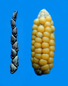
What artificial selection (as opposed to natural selection) can do; a teosinte seed head with a corncob. Source: Doebley Lab.
Through various means, usually by trade, corn was spread from Mexico throughout North and South America; in South America it was not only grown for food, but also made into a beer called chicha. But while corn did all right in the Andes, and in the northern temperate latitudes, the jungles of Central and South America were too wet to grow a good corn crop. Indeed, completely different rules for farming had to be followed here. The most common staple grown under these conditions was a root vegetable, manioc (also called cassava or yuca). Manioc is a valuable food source because it produces heavy yields, is tolerant of poor soils, and being a perennial, can be harvested at any time of the year; today it is widely grown in the tropical parts of Africa and Asia as well as the Americas. However, it also contains toxins that can cause a variety of diseases, if eaten raw; fortunately, cooking gets rid of the toxins. Because raw manioc is poisonous, it is amazing how important manioc is for the tribes of the Amazon basin, and African countries like Nigeria; for some people it makes up as much as 85 percent of their diet. Finally, manioc doesn't keep well; it starts to decompose almost immediately after picking. The best ways to preserve it are by drying, freezing, or coating the roots with wax, and that is why manioc is uncommon in U.S. supermarkets.
It may surprise the reader that tropical rainforests are not a good place for agriculture. While there may be enough water for any crop, the soil tends to be red or yellow in color, acidic, and poor in nutrients, because erosion and the abundant plant life have leached away the nutrients already. Most primitive cultures living in a jungle setting have practiced a very wasteful method of farming called “slash and burn” agriculture; they cut down and burn part of the forest, plant one crop after another until the soil is too depleted to grow any more, and then move on. Without advanced tools or a good source of fertilizer, this may be the only way to grow crops in such an environment. We thought this was the only livelihood of Amazonian tribes until the late twentieth century, when it was discovered that part of the Amazon basin, maybe as much as ten percent of the area, has an extremely rich, black topsoil, that in some spots is up to seven feet thick. In addition, it is one of the most stable soils anywhere; it keeps its fertility for many years before needing replenishment. It now appears that this terra preta--“superdirt”--does not occur naturally, but was produced when the natives supercharged it by mixing in ingredients like charcoal, pottery and manure. Read this National Geographic article for more about the discovery.
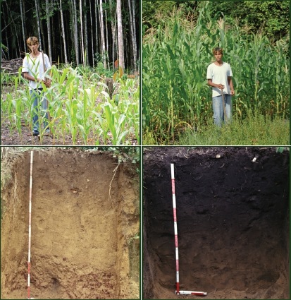
Comparing regular Amazon soil with superdirt. Source: the International Biochar Initiative.
What “superdirt” means to us is that the Amazon basin may have once supported millions more people than we thought; maybe even enough to build cities. Along that line, satellite pictures of the region have revealed hundreds of interesting shapes in the ground that appear to be manmade; circles, rectangles, lines, etc. Could these be structures like the Indian mounds of the eastern United States, the Nazca lines of the Peruvian desert, or something more elaborate, like walls and buildings? So far no lost cities have turned up in the Amazon basin, like those in the jungles of Guatemala or Cambodia, though over the years there have been plenty of stories suggesting that such cities might exist. At a minimum, I'll have to revise my estimate for the region's population in the pre-Columbian era (I said about 3 million in Chapter 2), if such cities turn up. Indeed, Francisco de Orellana, the first European to explore the Amazon, reported a dense population of natives living along the riverbanks, enough to give the region a total population exceeding that of today. Perhaps he wasn't really exaggerating after all.
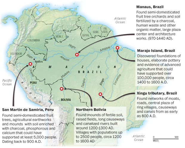
The most promising sites found so far. From The Washingtom Post.
We will finish this section with a few words about the tomato, another surprise of New World agriculture. Scientists have traced the homeland of tomatoes not to Mexico, but to the mountains of southern Ecuador and northern Peru. The original plants, Solanum pimpinellifolium (“pimps” for short), are very hardy, but not very appetizing; the fruits are tart, orange or yellow rather than red, and only as big as a pea; you will need to pick dozens to get enough for a salad. Unfortunately, today pimps are an endangered species; modern agriculture and herbicides have destroyed them in most of their habitat. Somehow, at an unknown date in pre-Columbian times, one Native American, or maybe a group of Native American traders, took the seeds of these ancestral tomatoes, while they were still unappealing, more than a thousand miles, from the place where they grew originally, to Mexico. That journey must have been a great adventure; it's too bad nobody wrote it down, for us to know what happened on the trip. In Mexico, those who acquired the seeds treated them the same way they had treated teosinte, breeding them to produce larger, more attractive and better-tasting fruits; today's name for them comes from the Nahuatl (Aztec) word tomatl. Spain introduced tomatoes to Europe in the sixteenth century, but for a while they were grown mainly as an ornamental plant, because Europeans thought they were poisonous. Moreover, since a ripe tomato does not stay fresh for long, they could not be transported far from where they were grown until canning and refrigeration were invented. Tomatoes grow best in warm climates; since Italy is known for its warm climate, the Italians experimented with tomatoes, and only after they perfected recipes that included tomatoes, did this New World import become popular with everybody else.
In the author's hometown is the headquarters of Fazoli's, a chain of Italian restaurants. These days, tomatoes are such an integral part of Italian cuisine, that the company logo features a tomato, rather than a picture of pasta or pizza.
![]()
Before the First Horizon
In the fourth and third millennia B.C., people in six locations made the climb upward from the stone age to civilization: Iraq, Egypt, Pakistan, northern China, Peru and Mesoamerica. For the four Old World civilizations, they all developed under very similar conditions, on the banks of a river running through a desert or semidesert, and two centuries of archaeological excavations have given us a good idea of how they got started; you can read what I wrote about that in Chapter 12 of The Genesis Chronicles. Coastal Peru is also dry, but instead of one big river, it had several small ones, so you could say Peruvian civilization developed on a string of oases. For the author, Mesoamerica is the most puzzling cradle of civilization, because this region is not known for deserts or rivers; in fact, the jungles of Yucatan and Central America make it one of the world's most inhospitable places. However, it wasn't until the second half of the twentieth century that archaeologists began to excavate Maya sites older than 300 A.D., so only now can we see the Maya civilization in its formative stage. It may turn out that the Maya and predecessors like the Olmecs followed a different formative process than the one we are familiar with--or the founders of those civilizations came from somewhere else altogether (Lake Texcoco comes to mind).
In the previous section, I mentioned that the oldest evidence of humanity in the western hemisphere is in South America. We also find signs of progress toward civilization in South America before it appears in North America, but here we know why. A lot of the artifacts found so far come from Peru, and the coastal plains of Peru and Chile are deserts, one of the driest places in the world. Indeed, the Atacama Desert of northern Chile receives an average of 1 millimeter of rain a year (that's 0.04 inches), and some weather stations in the Atacama have never received rain at all. Deserts are the best climate for preserving artifacts, so for all we know there could have been older human communities in wetter places, but their tombs, treasures, trash and tools did not last through the ages.
Though both the Andes and the east-to-west trade winds kept rain from falling on the Peruvian and Chilean deserts, it was still possible for even primitive folks to live there, because South America's west coast is also one of the world's richest fishing grounds. The cold Humboldt Current, running up the coast from Antarctica, provides very favorable growing conditions for plankton, and the plankton attracts lots of fish, especially anchovies and sardines. The fish in turn attract birds and mammals like seals and whales; the latter became big game for the more adventurous fishermen to hunt.(8)
When excavating Old World civilizations, we usually have inscriptions to help us understand what we're looking at, not to mention literature from other civilizations that lived at or near the same time (e.g., much of what we know about ancient Egypt and the Middle East comes from what the Greeks had to say about those places). Since we don't have any such commentaries for South American civilizations, all we have to go on are some oral traditions, which take us back to about a century before the Spanish conquest, and what the archaeologists dig up for the centuries before that. Thus, when we talk about South America before 1400 A.D., we will discuss art, architecture, religious customs, etc., but we won't have the names of great people or the dates of battles, and when a particular community is abandoned, your guess is as good as mine concerning why it happened.
For Peru, archaeologists classify artifacts according to technology, artistic style, age and geographical distribution. The key periods of technological and cultural development are called “horizons,” and are laid out in early, middle and late periods, with intermediate periods between them.(9) However, the borderline dates between these periods are chosen not by the rise and fall of great nations, as is done with Old World histories, but by years of severe droughts, which were probably caused by El Nino, the warm spells in the southeastern Pacific Ocean that can change weather all over the world.(10) You will notice, for instance, that in the table below, Tiahuanaco appears in both the Early Intermediate and Middle Horizon periods. Where possible, we will try to fit South American cultures beyond Peru, like the Muiscas of Colombia, into the scheme shown in this table.
| Preceramic (sometimes subdivided into six shorter epochs) | Before 1800 B.C. | Chinchorro, Valdivia, Norte Chico (Caral-Supe) |
| Initial Period | 1800-900 B.C. | Kotosh, Cupisnique |
| Early Horizon | 900 B.C.-200 A.D. | Chavin, Paracas, Pukara |
| Early Intermediate | 200-600 A.D. | Moche, Nazca, Lima, Tiahuanaco |
| Middle Horizon | 600-1000 A.D. | Muchik, Sican, Huari, Tiahuanaco |
| Late Intermediate | 1000-1476 A.D. | Chimu, Chincha, Chancay, Chachapoyas, Chiribaya, Chanca, Lupaca, Sican |
| Late Horizon | 1476-1534 A.D. | Inca |
The oldest evidence of South Americans advancing beyond a primitive hunting-gathering existence was found in a cemetery at Arica, in northern Chile. Other cemeteries have turned up at Iquique and Antofagasta in Chile, and Ilo in Peru. We call the tribe that lived here the Chinchorro, after a word meaning “small boat,” because they practiced fishing as well as hunting and gathering. Aside from the cemeteries, the only other sites left by the Chinchorro were middens (trash heaps). No cities or monuments were built, telling us that the Chinchorro community was limited to a few fishing villages.
If radiocarbon dates can be trusted, the age of the Chinchorro culture is astounding, going all the way back to 5000 B.C.! The cemeteries contained an assortment of mummies; some were produced by the extremely dry desert conditions, but most were mummified through artificial means. One mummy was dated to 5050 B.C., meaning that these are the oldest mummies in the world; Egypt did not start making mummies until after 3000 B.C. Our guess is that like the Egyptians, the Chinchorro noticed that dead bodies dried out in the desert and decayed in other places, got the idea that the former process was better, and they did what they could to duplicate it.
A few things about the Chinchorro can be learned from their burials. First and foremost, life was tough; a fourth of the burials were for children that were one year old or less. Many also show the usual infections and parasites picked up by primitive fishermen, and quite a few have fractures, suggesting that life in their villages was often violent. Still other mummies show signs of wear and tear, repair and repainting, evidence that the bodies were carried around openly for quite a while before they went to their final resting places; we will see other South American cultures treat the dead like holy icons or relics, especially the Incas. Finally, we can see that the Chinchorro had an egalitarian society. Whereas ancient Egyptian society concentrated power and wealth among a few families, to the point that mummification was unaffordable for at least half of the population, here it looks like mummification was given to everyone, even miscarried fetuses. For more about the Chinchorro mummies and how they were made, the author recommends this interview with Dr. Bernardo Arriaza.
The Chinchorro stopped making mummies around 1800 B.C., though their communities remained inhabited until at least 500 B.C. Meanwhile to the north, a hunting-gathering tribe, now called the Las Vegas culture (no connection with Las Vegas, NV), lived on Ecuador's Santa Elena peninsula. They were followed by the Valdivia culture (3500? to 1500 B.C.), which produced South America's oldest examples of the archaeologist's favorite artifact--pottery. Like the Chinchorro, at first the Valdivia mainly lived by fishing, though they also hunted deer on the side. And they practiced agriculture, learning to grow corn, kidney beans, squash, manioc, hot peppers and cotton plants; most of those plants first appeared in Mexico, meaning they were already introduced to South America before 2000 B.C.(11) Over time, the Valdivia villages grew larger, and agriculture became more important, because it allowed the villages to stay permanently in one spot. In addition, Valdivia ceramics became more elaborate, turning into high quality works, showing that the potters who made them were specialists, not people who worked on them part-time, when they weren't busy with planting or harvesting. Besides pots, they produced the oldest New World sculptures, clay figurines of women that we call “Venuses.” Each Venus looks different from the others, usually with an individual hairstyle, hinting that they were modeled after real women, instead of just following artistic traditions.
Between the Chinchorro and Valdivia cultures, a third culture arose on the coastal plains of northern and central Peru, and this one was the most impressive. We call it the Norte Chico culture, after the modern name for that part of Peru, or the Caral-Supe culture, because the most important site found to date was at Caral, in the Supe valley. Between 3000 and 1800 B.C., the Norte Chico built at least thirty towns; Caral had a population of about 3,000 in its heyday. The first towns were all along the coast because the residents ate seafood most of the time, especially anchovies. What impressed the archaeologists the most was that the towns had monumental architecture, such as sunken circular plazas and great earthen mounds, artificial hills that can be called the world's oldest pyramids. The typical ceremonial complex was a U-shaped structure, one large mound flanked by a smaller mound on each side, facing a sunken plaza. La Galgada, in the Rio Santa drainage basin, is probably the oldest complex (occupied 3000-2000 B.C.). The largest complex, at El Paraiso just north of modern Lima, covered 140 acres and required moving or using 100,000 tons of stone. Presumably the towns had a strong government to build and maintain these structures, but we have no idea how it worked. Their houses were built from a combination of adobe, wooden poles, cane and mud, and the residents appear to have made a living by bartering and working with cotton.
On the other hand, the Norte Chico had no pottery and almost no art(12), reminding us that primitive civilizations can be very different from one another. Even more interesting, no weapons have been found, nor are there any defensive works like walls. Finally, there is no evidence of human sacrifice, a custom we will see all too often in other pre-Columbian civilizations; however, evidence of drug use, another common practice in ancient American religions, has been found.(13) The overall impression we get is that the world of the Norte Chico culture was peaceful, where technology was used to improve food production or make the environment more comfortable, instead of inventing new weapons or finding ways to concentrate the land's resources in the hands of a few people.(14)
As irrigation and other agricultural techniques improved, new towns were built inland, where conditions were better for growing cotton; Caral was one such mountain community. Peru's geography put three extreme climates close together—the coastal deserts, the Andes, and the eastern jungle—so having communities in the central highlands made it easier for the people in all three zones to trade. Common trade goods included fish and seashells from the coast, crops like potatoes and sweet potatoes from the mountains, and exotic products like parrot feathers from the jungle. Then after 1800 B.C., the Norte Chico culture faded away. Why their civilization disappeared is a mystery; did the people living there simply move to another place?
The last important preceramic site was Kotosh, near present-day Huanuco, Peru. Kotosh was inhabited from 2300 to 1200 B.C., and it contained an elaborate stone temple structure, where the dominant symbol was an image of two crossed arms. This is the oldest temple in the Americas. On the coast, near Chan Chan (an important site we'll be hearing about later), a culture we call the Cupisnique raised adobe buildings, and made the first fine clay pots in South America. Many of the pots are in a style we call stirrup jars, because they had ring-shaped spouts instead of handles. The most important years for the Cupisnique were between 1500 and 1000 B.C., but their sites remained inhabited until at least 200 B.C., and their style of art was copied for some time after that. After 900 B.C., coastal Peru came under the domination of the Chavin culture; unfortunately we don't know what the relationship was between the Cupisnique and Chavin. The Chavin were the most important culture of the Early Horizon period, so we will look at them in another section, but now it is time to go north of the equator to see how civilization is developing there.
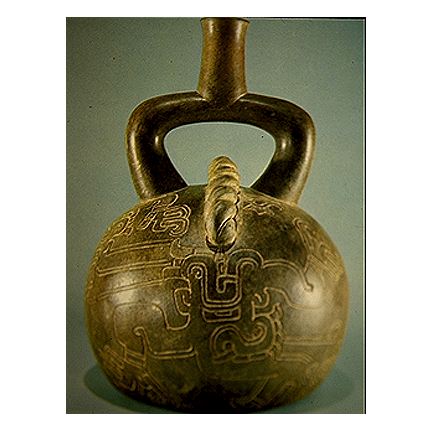
A Cupisnique stirrup jar.
The Mysterious Olmecs
By 1500 B.C., farming in central and southern Mexico had advanced to the point that the farmers could stay in permanent villages. The next few centuries saw living standards improve, which first appears to us in the form of better, more elaborate pottery. A trading network developed; the main commodities traded were shells and valuable stones like obsidian, serpentine, and jade.(15) If a village was located near an interesting natural feature, such as a cave or spring, it would acquire supernatural significance (e.g., the natural feature could be seen as the birthplace of a god), and a ceremonial center might be built to mark the spot. For this task, labor was organized enough to allow the cooperation of several villages; the resulting plazas and mounds were large enough to hold far more people than those who lived locally. The ceremonial centers also mark (as in Peru) the rise of a class of shamans, or holy men, because we now can see that the villages had the resources to support them. These shamans would become the educated elite, the priests and rulers that so dominated Mesoamerican civilizations from here onward.
Northern Mexico is too dry to grow crops on the scale that we see in the central and southern parts of the country. This meant that communities were smaller, and the natives living there could not quit hunting and gathering. The need to supplement their diet with hunting trips kept them seminomadic. In the process of following game they must have crossed into the lands of the future United States several times, and taught the techniques of growing corn to the ancestors of the Hopi, Cherokee, Iroquois, etc; the tribes living north of the Rio Grande had all been strictly hunter-gatherers previously.
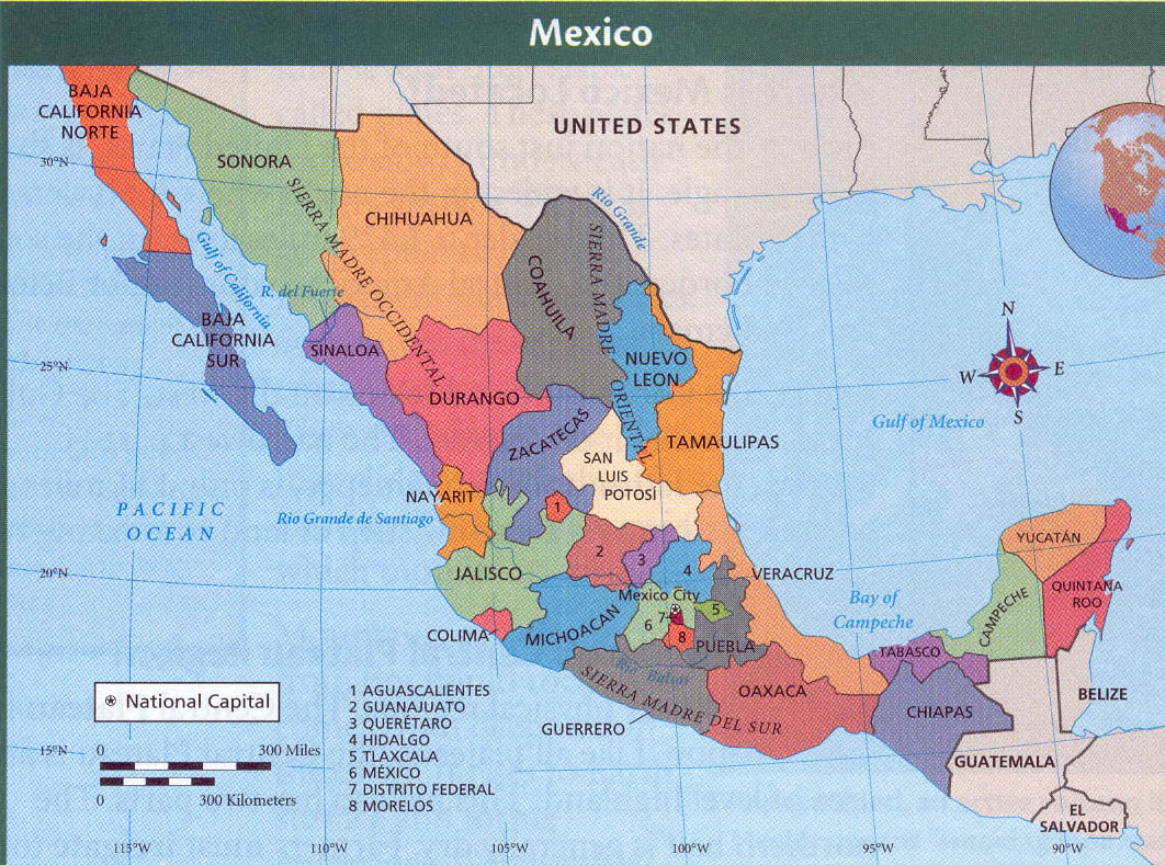
A thumbnail map of Mexico, for those unfamiliar with where all the Mexican states are. Click on this thumbnail for the map to open in a separate window.
The oldest Mesoamerican civilization rose near the Bay of Campeche, the southernmost part of the Gulf of Mexico. We call these people the Olmecs, but everything we know about them generates questions. To start with, Olmec is a name of convenience, because we don't know what the “Olmecs” called themselves. In the sixteenth century A.D., there was a tribe called the Olmecs, meaning “rubber people” because rubber trees were common in the neighborhood, but they were related to the Aztecs, and aside from the location, they probably had nothing in common with the people we're talking about. It is more likely that the original Olmecs were related to both the Maya and the Huastecs(16), because they lived right between these two groups. Perhaps “Tamoanchan” is the name we are looking for. Later on an Aztec myth would assert that the gods created the first human beings in a paradise called Tamoanchan, and that it was a “land of rain and mist,” located on the “Eastern Sea.” However, this is a word of Mayan origin, so for all we know it could be a Maya memory of where they or the Olmecs came from.
The Olmecs did not build an empire; they probably did not even have a unified state. More likely the Olmec region was a network of city-states, each ruled by a theocracy where the leaders were both kings and high priests. Their religion was fixated on the jaguar, the largest cat living in the New World; because pre-Columbian Indians never saw a lion, the jaguar would have been the “king of beasts” to them. The most common art subject for the Olmecs was a man or infant with jaguar features, especially fangs. Those familiar with stories about werewolves will call this humanoid a werejaguar; the Nahuatl word for a were-creature was nagual. Apparently the Olmecs believed that their chief god, or their most important ancestor, had the power to change into either a human or a jaguar. They also believed in the animal spirits we call familiars; many, if not all Olmecs, had an animal companion, which they thought was a nagual. The relationship between human and nagual was closer than that between us and our pets, to the point that if the human died the animal was expected to die, and vice versa. We have an example of this from the tomb of a royal family, where an infant was buried with two jaguars, which were probably the child's naguals.
There is no evidence that the Olmecs had a standing army, but they must have thrown a scare into their neighbors. Other tribes would have seen the Olmecs as people who claimed to be descended from jaguars, and practiced ritual bloodletting--possibly human sacrifice, too. Olmec rulers also had the power and knowledge to persuade/coerce more people than anyone else, allowing them to outdo all their predecessors in what they could build. Their first ceremonial center went up around 1250 B.C., at San Lorenzo, a site on the Coatzacoalcos River, forty miles from the sea. This location was less swampy than other lands south of the Bay of Campeche, but still it received abundant rainfall and was thus blessed with a great variety of plants and animals; farmers living there could grow two crops a year. The main feature of the site was an enormous mound 150 feet high, which served as a platform for the mounds and courtyards built on top of it. When seen from the air, the structure looks like an enormous bird flying east; the builders may have meant it to resemble that.
The builders did not stop with the mounds and courtyards; they also carved colossal stone heads, the most famous Olmec artifacts. The heads wear round helmets and have flattened noses and lips; the largest is eleven feet tall and weighs more than 25 tons. Most historians believe these represented Olmec priest-kings.(17) Seventeen stone heads have been found so far, ten of them at San Lorenzo. Some heads show traces of purple paint; they were painted with a purple dye made from a shellfish, very much like the murex dye which made the Phoenicians famous.
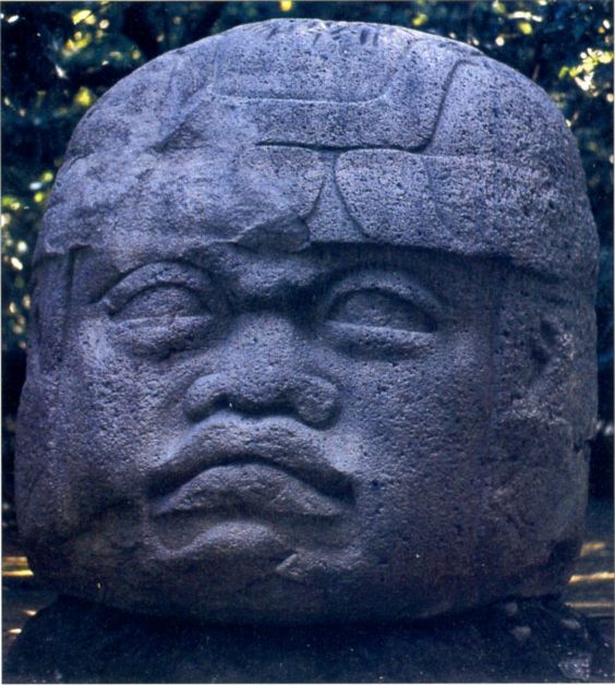
An Olmec stone head.
For the next three hundred years the Olmecs were successful. Their population grew, and their rulers built new stone monuments: thrones and relief sculptures to go with the other monuments already standing at San Lorenzo. Most of the time they traded with or formed marriage alliances with other tribes, but the werejaguar people were able and willing to impose their will by force if the neighbors did not cooperate. Olmec trade goods, art styles, and cultural traits like religious beliefs appear as far away as Honduras in Central America, and in western and central Mexico; for a people who had to do all their traveling on foot, their merchants, artisans and tribute gatherers really got around. The most distant Olmec site from their homeland found to date is Zazacatla, which is located twenty-five miles south of Mexico City and was discovered in 2006. Zazacatla was occupied from 800 to 500 B.C., and here it looks like a local tribe adopted the Olmec culture; statues show their chiefs wearing Olmec-style emblems, meaning they now had the same sort of hierarchy that existed in the Olmec realm. But Olmec power had its limits, and at some time between 950 and 900 B.C., a rebellion brought down the system.
Without writing, we can't be sure what happened. It looks like population pressure strained the economy, which finally broke when famine struck. We now know that a change in climate around 900 B.C. made the Old World cooler and less pleasant, leading to violent events like the Trojan War; it's not hard to imagine the same thing happening in the New World. The rebels--possibly starving peasants--desecrated San Lorenzo by toppling and defacing all its monuments. Objects too large for the rebels to destroy, like the stone heads, were buried instead. However, this wasn't the end of the Olmec civilization, only a setback. When order was restored, a new ceremonial center was built at a new site, La Venta in the state of Tabasco. The main features at La Venta were four more stone heads, and a 103-foot-high hill, which is shaped like a volcano and overlooks a great plaza. Though the hill was made of earth, not stone, we call it Mesoamerica's first pyramid, because it looks like the pyramids built by the Olmecs' successors (see footnote #3).
This time the Olmecs were not content to have a single ceremonial center; they built another one at Copalillo, 400 miles west of La Venta in the state of Guerrero. On the site they erected the oldest known stone temple in Mesoamerica, by carefully fitting together huge blocks of travertine marble. When finished the temple included an aqueduct, a stone drainage system, and an indoor ball court for their favorite sport. However, it never grew large enough or important enough to replace La Venta, due to the region's economy; the local peasants could only grow enough food to feed (at most) a thousand priests, nobles, retainers and artisans, compared with about ten thousand specialists for La Venta.Because the priests were the educated class, when they weren't busy developing their theology, they followed other intellectual pursuits that would bring tremendous benefits. The most important was the invention of the first American calendar, which happened after they calculated the length of the year and how long it took for the moon to complete one orbit around the earth. The main purposes of the calendar were to keep track of holy days and to know the times for planting and harvesting, but they didn't stop there. The first calendars used in the Old World followed a relative dating system; whenever those civilizations got a new king, the calendar makers went back to year 1 and started counting the years all over again. Instead of doing this, ancient Americans followed an absolute dating system, counting the number of years from a fixed date in the distant past; the starting date marked the time when they believed a critical event took place, like the creation of the world or the birth of the gods.(18) At the same time, they developed a form of picture writing to go with the calendar: ovals, dots and horizontal lines to represent numbers(19), and elaborate glyphs to represent words. Alas, only a few examples of Olmec hieroglyphs have been found to date, so we have not deciphered them yet.
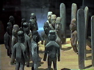
At La Venta, a set of figurines was buried in the sand. Here they have been arranged in the same positions that they were found in, standing in front of six inscribed stones we call celts. Obviously the scene is supposed to represent some kind of meeting; which one do you think is saying, "I suppose you're all wondering why I called you here?" Nobody knows what the meeting was about, except maybe for two Chinese scholars, who translated the symbols on the celts and announced the figurines represented Chinese settlers, who had just crossed the Pacific and were establishing a new country! Go to Chapter 1, footnote #15 of my North American history for more on this provocative theory.
As with San Lorenzo, the good times at La Venta and Copalillo lasted approximately three hundred years. Then around 600 B.C., Copalillo was suddenly abandoned. La Venta hung on until 400 B.C., and then it came to a violent end. Twenty-four of La Venta's forty major monuments were defaced and buried; our guess is that an uprising like the one that destroyed San Lorenzo took place here. This coincided with a sudden depopulation; between 400 and 350 B.C., population in the eastern half of the Olmec realm (modern Tabasco) plummeted, and did not recover until the nineteenth century. The reason for this loss in people may have been a change in climate, volcanic eruptions, or a silting up of the rivers from bad agricultural practices. West of La Venta, a ceremonial center at Tres Zapotes escaped destruction, so it became the last Olmec capital. Here the Olmecs continued their trade and craftsmanship, but they only carved two stone heads and built no more great monuments. Tres Zapotes remained occupied until the Maya took over; some scholars call the culture at this site “epi-Olmec” or “post-Olmec.” Izapa, a site located in the state of Chiapas, also shows a transition between the Olmec and Maya cultures, but here it looks like another minor tribe civilized itself along Olmec lines.
Because no civilization older than the Olmecs has been discovered in North America, we see the Olmecs playing the same formative role that the Sumerians played in the Old World. All the basic elements of Mesoamerican civilization appear to have started with them. The Mesoamerican calendar, system of writing, religion--even their ball game--were changed over the ages by the Maya, Aztecs and others, as you might expect, but still they are all part of the Olmec legacy. Even their places of worship weren't completely deserted; Indians of later generations and tribes continued to bring offerings to La Venta and Copalillo; in our own time, archaeologists digging there have reported natives coming at night, to pray in ancient languages to forgotten gods. And all this was accomplished over a period of a thousand years by a people who never had the wheel or a code of laws, and who built everything with their own muscle power.
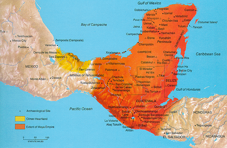
Use this map as you continue to read this chapter, because most of the Mesoamerican sites mentioned are shown here (click on it to make it open in a separate tab/window). The Olmecs lived in the yellow zone, and the Maya lived in the orange zone.
![]()
The Chavin Culture: Peru's Great Leap Forward
Many years ago in the author's home town, the local newspaper ran a cartoon where two explorers in a jungle meet a nearly naked native, and one explorer says to the other, “He said he's never heard of war. That should tell you how uncivilized they are.” In pre-Columbian Peru, it now looks like that joke came true; the peaceful Norte Chico culture was replaced by civilizations that were more advanced (technologically, politically and socially) and more warlike at the same time. The first of these was the Chavin culture, which lasted from 900 to 200 B.C. and is named after Chavin de Huantar, its most important site. Though Chavin de Huantar rests more than 10,000 feet above sea level, it is also at the junction of the Mosna and Wacheksa rivers, and is in one of the few mountain passes going through the central spine of the Andes, the Cordillera Blanca, so trade routes from both the coast and the tropical lowlands came here.
In ancient times, competition for the best farmland and sources of water was one of the biggest reasons to start a war. We see it in the Sumerian wars of the third millennium B.C., and in nearly every Old World conflict involving barbarism vs. civilization, the barbarians were the poorer group, seeking to take what civilized men already had. These conflicts happened more frequently in tough times, when essential resources like food were in short supply, and in the previous section, we saw that world climates took a bad turn around 900 B.C., the time when the Chavin culture got started. For South America, this meant another period of droughts. Fortunately, any conflicts over resources would have been short, and not as bloody as similar conflicts in future ages, because the world had a much smaller population; small communities at this early date meant it was easier to provide enough living space, food and water for everybody.
We don't know where the founders of the Chavin culture came from, except that it was somewhere in northern Peru. At Cerro Sechin, the oldest site where they left monuments, they carved hundreds of relief sculptures showing mutilated or dismembered human victims in graphic detail, evidence of either violent conflict or the first practice of human sacrifice in South America. Usually the image is a triumphal scene, where an important person wearing a loincloth and hat, and carrying a club or staff, marches in victory. This is what tells us that the Chavin culture was initially spread by force; apparently Chavin warriors were motivated by the zeal of a new religion as well as by hardship at home. However, the Chavins did not conquer their neighbors so much as they converted them; they built no defensive fortifications like walls, nor is there evidence of an imperial administration, or garrisons stationed in towns. Once the initial invasion was over, they seem to have used the power of images and ideas, rather than the strength of soldiers, to impose their authority.(20) At the Norte Chico sites, the Chavins did not destroy the older ceremonial complexes, but remodeled them according to the new creed's tastes.
The Chavin period is the only time in pre-Columbian South America when religion seems to have dominated life as completely as it did in the Mesoamerican civilizations. By contrast, later South American civilizations, especially the Incas, were more interested in managing their land and people effectively. For the best look at the Chavins, we have to examine the Chavin de Huantar temple. The stones of the temple are covered with images that combined features from humans, jaguars, caimans, snakes, and birds of prey like eagles; all are easy to recognize because the artisans kept their carvings simple (they probably did not want to carve too much with the primitive tools that passed for a hammer and chisel). Among those creatures, the jaguar and the caiman ruled the rest; stone feline heads are common, and all the images at least have cat fangs or alligator teeth. It is also interesting that none of the plants and animals represented in the temple are species native to the neighborhood; many come from the jungle east of the Andes. The most important image is a snarling deity on a 15-foot granite pillar called the Lanzón (lance), located at the junction of two underground passages; we believe that worshipers were drugged with mescaline and led through pitch-black tunnels to meet this god. It also appears that the Lanzón served as an oracle; by speaking through the hole above the shaft, a hidden priest could make the uninitiated think the Lanzón talked.
We know how South American oracles worked because Miguel Estete described one of the last of them, at Pachacamac, in 1534 A.D. Located near Lima, this site had seventeen adobe pyramids, the oldest dating back to 250 A.D.; it was considered a holy place for the Inca god that created the earth, also named Pachacamac. Pilgrims seeking advice on farming or personal matters came from all over the Inca Empire, bringing offerings of textiles, corn, dried fish and gold. To be admitted into the lower plaza, so they could attend the ceremonies held there, supplicants had to abstain from salt, chili peppers and sex for twenty days. Most pilgrims probably only went this far; to go to the upper plaza, where they had the right to ask questions of the oracle, the time of purification was extended to an entire year. But even then the supplicant simply gave his question to the attending priests, who then went to the idol, a large wooden pole with two human faces on top, and asked the question again. The oracle itself was hidden behind a cloth veil in a windowless chamber, and its answers (not to mention requests for more offerings) were relayed by the priests back to the supplicants. When Tupac Inca Yupanqui, the tenth Inca ruler, conquered Pachacamac in the fifteenth century A.D., even he had to do penance for forty days before he was allowed to consult the god. Because Chavin de Huantar had so many terraces and hidden tunnels, we think similar arrangements were made for the oracle it had.
In addition to the sculptures, a system of canals and conduits diverted water from the nearest river under the temple complex, creating a roaring sound during the flood season, and archaeologists have found several conch shells imported from the coast, for use as trumpets. At times of worship, the priests wore impressive gold headdresses and gold jewelry, and used drugs derived from coca and cacti (see footnote #13) in their rituals. Finally, a hidden stairway allowed priests to magically “appear” on top of the temple. Obviously the priests designed the temples and rituals to make the most of light, sound, and any other sensory stimulation available, to look awesome to everyone else.
Chavin de Huantar appears to have been a place of pilgrimage, rather than a true capital city. Although the central plaza is a perfect 49-meter square, making it more than half the size of a modern football field, there were not enough houses and other buildings for a large permanent population. Besides the clergy, craftsmen and artisans lived there, for the jobs of weaving, tanning hides, sculpting, and making various objects out of metal and gemstones. With gold, silver and copper, Chavin metallurgists not only knew how to smelt and shape those metals, but also how to solder them. Gold was popular among the upper class not because it was rare or used for money, but because it represented the sun, crops ripe for the harvest, and eternity (gold does not rust or corrode).
A series of famines and floods in the middle of the first millennium B.C. persuaded many desperate people to accept the Chavin religion. Around 400 B.C. the Chavin culture peaked, with the cult of its temples practiced over an area of 77,000 square miles. A couple of centuries later, though, the Chavin rulers, high priests and builders disappeared. The ceremonial centers were abandoned, and hilltop forts took their place. As with the Norte Chico, no evidence was left behind to tell us what happened; perhaps the religion split into smaller sects, each too weak to stand on its own in a more turbulent world. But just as the Olmecs did for North America, the Chavins left their mark on South America. The chief gods of every Andean civilization after that, up until the Spaniards arrived, all resembled the fierce-looking jaguar-man god in the temple at Chavin de Huantar.
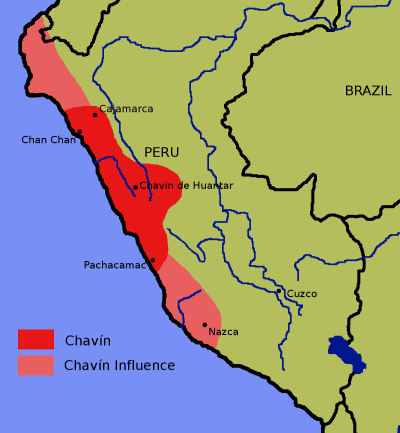
Chavin-era Peru. From Wikimedia Commons.
The Paracas: Dream Weavers
The above map shows the Chavin area (red) and the areas it influenced (pink). The southern pink zone was the domain of another culture that existed at nearly the same time (800-100 B.C.), around the Paracas peninsula. These people built no large buildings, and instead of worshiping creatures that were part man and part animal, they venerated their ancestors; by doing this, they introduced the burial customs that the people of the Andes would practice for the next two thousand years.
Everything we have from the Paracas culture was found in their cemeteries, especially on the arid peninsula itself, which is bone-dry because no rivers flow there and it almost never receives rain. The deceased were placed in a sitting position in a basket, and wrapped with many yards of cloth, turning them into mummy bundles. Besides blankets and burial shrouds, pieces of everyday clothing like mantles, ponchos, turbans, tunics, skirts and loincloths were used in the wrapping. The poor got plain wrappings, while the upper class received cloth with dazzling patterns. No attempt was made to embalm the body, but because the burial place is so dry, the bodies were preserved naturally. The same conditions preserved the cloth, which has colors as brilliant as when it came off the loom. Pottery, jewelry, food, and other objects that the dead might need in the afterlife were placed in the bundles, or buried next to them. Often a grave would be large enough to accommodate several bundles. Sometimes the rich and poor were buried together, showing us that while class distinctions existed, they were not yet considered very important.
Unfortunately no Paracas looms or spindles have been found, so we don't know how they did their intricate weaving. Several different styles were used for the patterns, leading the archaeologists to try dating the burials by style of cloth as well as by style of pottery. Either vicuna wool or cotton might be used for the fabric, and the three most common styles are called block color style, linear style, and broad-line style. The linear style uses four colors and narrow lines, while the broad-line style has more than one row of the same color threads running parallel, to produce bands instead of lines. Block color style is the most realistic; with as many as 500 threads to the inch, it allows very detailed images with curved lines (the other two styles allow geometric figures only). Common art subjects for the textiles included felines (a idea from the Chavins, no doubt), snakes, fish, eagles, a big-eyed god archaeologists call the Oculate Being, and shamans. The latter were often shown with an arched back (as if they were flying), a staff and a fan held in the hands, and a grin; we call this the “ecstatic shaman,” because after taking hallucinogenic drugs, he dreamed of flying to another dimension.(21)

The three Paracas weaving styles.
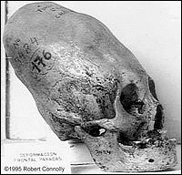
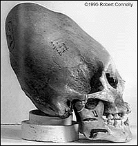
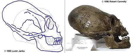
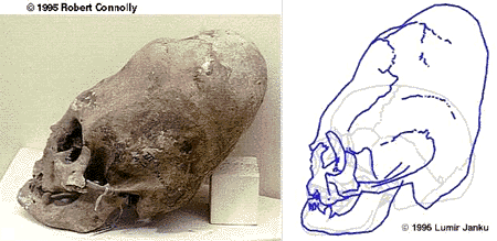
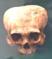
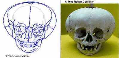
The Paracas did not just do amazing things with textiles; they also altered their own heads. Many of the skulls of the deceased had holes bored into them, a form of surgery called trepanation. They may have done this to repair skull fractures, treat migraine headaches, or cure psychological disorders. Using drugs like coca and alcohol as anesthetics, a piece of the skull was removed and covered with a gold plug and bandages. Quite a few patients survived the operation, as shown by skulls where the bone grew back, shrinking the hole. Even more unusual, they reshaped the heads of upper-class infants by wrapping boards and bandages around them, to produce an elongated skull with a sloping forehead, or a skull shaped like an incandescent light bulb. The only way to explain this is to say that different cultures have different standards of beauty, though a modern observer can be forgiven if he sees a reshaped Paracas skull and thinks it is not human. Indeed, photos of the skulls have been posted on websites, forums and newsgroups as “evidence” of space aliens visiting prehistoric Peru. One website, NephilimSkulls.com, even claimed they were the remains of giants who lived before Noah's Flood. Most of the skulls belonged to adults, so they cannot be dismissed as birth defects, which are likely to kill the afflicted person in infancy.
 |
 |
 |
 |
 |
 |

Two hundred years after the last Paracas burial, the Nazca culture appeared in the same part of Peru, so it looks like the Paracas people and culture did not really disappear; they became the Nazca culture. Meanwhile to the southeast, a dozen temples were built around Lake Titicaca, on the Peruvian-Bolivian border, between 300 B.C. and 300 A.D. We call the religion practiced at these temples the Yaya-Mama cult (Quechua for “Father-Mother”), because the temples featured male and females figures facing one another. As for the builders, we call them the Pukara culture, but aside from the temples, nothing is known about them. They may have been the forerunners of the more impressive Tiahuanaco culture, just as the Paracas were ancestors of the Nazca.
![]()
The Zapotecs
The Olmecs were on the verge of literacy when they disappeared. Every ancient civilization that invented writing did it for a specific purpose, and used the symbols they came up with for other purposes later. In Mesopotamia, cuneiform was first used for business records; in China, writing first appears on “oracle bones”; in Egypt, we found the oldest hieroglyphics on the seals of wine jars in the tomb of the Scorpion King (the Egyptians kept track of the vintages and amount of wine buried with the pharaohs). With Mesoamerica, writing was first used to record names, then historical events.
The oldest historical inscriptions found so far in the Americas are at Chiapa de Corzo (36 B.C.), in the state of Chiapas, and at Tres Zapotes (31 B.C.), which we noted was the last Olmec ceremonial center. In both cases, they carved a date on a stone stela, using the “Long Count” calendar for their reckoning.(22) Many Mesoamericans were named after their birthdays; for example, Eight-Deer, a Mixtec king we'll be hearing about later in this chapter, got his name because he was born on a day that was also called Eight-Deer. The result was that instead of writing “Achilles slew Hector,” an ancient American author would have written “January 7 slew July 12.” Thus, once you have a working calendar, all you need is a symbol for the word “slay” or “slew,” and it becomes possible to write true history.
The Zapotec Indians in the state of Oaxaca (pronounced “Wa-ha-ka”) learned how to write their names around 600 B.C., at San Jose Mogote. While they were building their greatest city, Monte Alban, they learned how to write history, too. This community was founded around 500 B.C., but most of the construction took place between 100 B.C. and 200 A.D., when an estimated 17,200 people lived there. The site they chose was a mountain that rose 1,300 feet above the surrounding countryside; any buildings put up there were guaranteed to make an impression. The slopes became a cemetery for more than 170 Zapotec nobles, while the top was leveled to create a flat area, about 3,000 feet across. After the clearing was finished they built pyramids, plazas, and a ball court on top of the plateau. Most of the stone used had to come from the lowlands, and without wheels or beasts of burden, just getting it up there was a major achievement. The Zapotecs probably conscripted work crews, making them haul and carve the stones instead of paying taxes; thousands of workers would have been needed. The pyramids show us that they started by following the basic Olmec design, but instead of just making hills, they gave the pyramids an outer layer of stone; in sculpture and pottery the Zapotecs also developed a style of their own.
The strangest feature at Monte Alban is a set of more than 300 relief sculptures, found mostly around the structures called Building J and Building L. Carved early in the period when Monte Alban was inhabited, they show people in unnatural poses, with their eyes closed, mouths open, and curlicues on their bodies that appear to be gaping wounds; their names appear as glyphs near their legs. Originally these were thought to be dancers, and the reliefs are still called Dazantes for that reason; the politically correct opinion is that these represented dancers in ecstacy, or that they were injured people waiting for medical treatment. However, it appears more likely that these were people who were dying, if not dead already; they must have been victims of war or ritual sacrifice. We don't know if Mesoamericans had practiced human sacrifice previously, but it was their most important religious rite now, and would remain so until the Spanish conquest. Another building's walls show many upside-down severed heads, with glyphs beside each one to give a date and the name of a town. No doubt this was a record the Zapotecs made of their conquests, when they expanded their realm.
The ball court is there because the Zapotecs saw religious meaning in their national sport. For the Zapotecs and other Mesoamericans, the ball and the players formed a kind of allegory, representing a battle between the gods, movements of the sun and stars, the cycle of fertility, etc. For the Maya, the game reminded them of a scene from their favorite story, the Popul Vuh (see below), when the Hero Twins battled the Lords of the Underworld in a ballgame. The rules probably changed over the ages, and the name of the game certainly did (e.g., pok-ta-pok to the Maya, ullamaliztli to the Aztecs), but it was equally popular wherever it was played. Indeed, an ancient ball court has even been found at a Hohokam site in Arizona.
In all cases, the object of the game was to make a rubber ball go through one of the stone rings placed on the sides of the court. Players were not allowed to kick the ball or use their hands; they had to hit it with their knees, elbows, hips or head. Being solid rubber, and not inflated like today's soccer balls, the ball could cause serious injury if it hit bare flesh, so the athletes wore leather guards or padding, and sometimes helmets. It was very hard to send the ball up the sloped sides of the court to enter a ring just right, so scoring a goal was rare; sometimes a game could go on for days, until a player finally scored.
The ballgame meant a lot to Mesoamericans. Teams could represent rival political factions, or a game might be used to settle a major dispute, instead of settling it by going to war. Sometimes the losing team became slaves of the winners. They might even sacrifice a team captain after a game, using him to carry a message to the gods. However, it is unclear whether this was done to the captain of the losing team or the winning team. It is hard to believe that they thought the gods would accept a losing player offered to them, but on the other hand, the players would have a very strong incentive not to play their best, if winning the game meant losing your head!
Modern Mexicans and Central Americans still play the pre-Columbian ballgame, though without the elaborate stone courts and human sacrifices. This video shows a re-enactment where the players wear ancient costumes. Watch the guy with the orange feathers!
![]()
Rise of the Maya
The period of Mesoamerican history from 400 B.C. to 300 A.D. is called the late Pre-Classic era, because this was after the Olmec civilization fell, but before the Maya civilization was fully developed. For a long time it was felt that the Maya had the first Mesoamerican civilization; now we know that they borrowed as much from the Olmecs as the Romans borrowed from the Greeks.(23) From the Olmecs they got writing, the calendar, the use of jaguars as a subject for art and religion, their favorite ball game, and a fondness for jade. Throughout the ages the Maya have lived in the same area where you find their descendants today: Yucatan, Guatemala, Belize, and part of Honduras and El Salvador.
The birthplace of the Maya civilization was either in or near northern Guatemala, on a steamy, jungle-covered plain now called the Petén. The oldest sites which have been identified with the Maya are Cuello in northern Belize (2600 B.C.), and Soconusco on the Pacific coast of Chiapas (1800 B.C.). At this stage they already had agriculture, permanent villages, and ceramics. Next, villages had to grow into towns, and it appears that the first community to do that was Nakbé, in the Petén itself. First inhabited around 800 B.C., Nakbé produced a grand ceremonial center more than half a mile across; small 60-foot-high pyramids were built there, starting around 600 B.C. After that they covered up their old ceremonial centers with platforms, and built pyramids up to 150 feet high, finishing them by 300 B.C. At this date they introduced stucco paneling to the monuments, replacing blank surfaces with what appear to be the faces of monsters.
A common feature of Maya architecture in the Classic era were stellae (plural for stele or stela) that showed the achievements of their rulers, with glyphs giving the date when the event happened. By contrast, Nakbé's art showed mainly gods and scenes from mythology. The most unusual monument was an eleven-foot-high stela that had been smashed to bits, for reasons unknown to us. When the archaeologist who found it, Richard Hansen, put the pieces back together, they showed two individuals dressed in old-fashioned royal costumes. One of the figures pointed up to a floating profile head, loosely joined to the headdress of the other. Hansen identified them as Xbalanqué and Hunahpú, the Hero Twins in the Maya creation myth, the Popol Vuh. Because the oldest work on this subject from anywhere else is dated to 200 B.C. (a relief sculpture found at El Mirador in 2009), this led him to ask: Did a new religion get the Maya civilization started, just as it did for the Chavin in Peru?
Nakbé is also where we first see the Maya standard of beauty. Some skulls found had teeth decorated with jadelike stone, and a fragment of pottery showed a face in profile with a sloping forehead (like the Paracas, the Maya reshaped the heads of their babies). Crossed eyes were also prized, to the point that they would dangle objects in front of infants to permanently cross their eyes (Imagine what they would have thought of Ben Turpin, the cross-eyed actor in silent films of the 1910s and 20s!). Because these practices were done mostly by the upper class later on, they suggest to us that a social hierarchy already existed in Nakbé.
Nakbé was abandoned after 300 B.C.; a small community occupied the ruins late in the Classic era, leaving some pottery, but no more monuments were built. The site was eclipsed by an even more impressive Pre-Classic community, El Mirador, which was built just nine miles to the north. El Mirador was founded in the sixth century B.C., and enjoyed its peak years between 300 B.C. and 100 A.D. It had two advantages that probably persuaded the Maya to move there; it had a better supply of water, and it had natural defenses--steep cliffs protected the north and west sides, while swamps protected the east side. Thus, the only easy to get to El Mirador was from the south; there was even a causeway joining El Mirador to Nakbé. The defenses were important because Maya communities were fighting among themselves already.(24)
El Mirador was easily the largest Maya city. With an estimated population of 80,000, it exceeded even those cities built later during the Classic era.(25) Whereas each pyramid built in other Maya cities was a single structure, El Mirador had “triadic” pyramids; the inhabitants constructed immense stepped platforms, larger than even those at Nakbé, and built three pyramids on each one. There were three of these complexes, now called “El Tigre,” “La Danta,” and “Los Monos.” The largest of these, La Danta, rises 230 feet from the forest floor. Like the pyramids at Nakbé, these pyramids were covered on the outside with plaster and stucco to give the appearance of masks from a distance, and painted red and white. The complexes are arranged together so harmoniously that a Guatemalan archaeologist, Carlos Morales-Aguilar, proposed that El Mirador's layout was planned from the start.
El Mirador.
Impressive as all this was, El Mirador had a rival, Kaminaljuyu, located in the highland valley that also contains Guatemala City. The name of this site is modern, meaning “place of the ancestors” in a Mayan language, and it was settled from 1500 B.C. to 1200 A.D. Curiously, all the structures found there were made of adobe, a building material normally used in drier climates; a shortage of building stone may have prompted the natives to do this. Olmec-style jade objects tell us that Kaminaljuyu traded with the Olmecs, and control over a nearby obsidian quarry at El Chayal made the city prosper (we'll see how this helped Teotihuacan in the next section). Kaminaljuyu also left several inscriptions among its ruins, while El Mirador left hardly any; apparently the Maya developed writing in the highlands first, and the northern lowlands and Yucatan became literate much later.
At Cerros, a coastal community near Cuello, we see clues on how Maya society evolved into a monarchy. Founded in the fourth century B.C., Cerros became a bustling port, and by 50 B.C., its population grew to the point that it could afford to build temples and ball courts. Our guess is that other communities like El Mirador already had kings, leading the elders of Cerros to believe that they needed a king, too, so they could trade with the other communities as equals. Although the people left no written record of what they did, they left us an archaeological record. First they tore down many old houses on the edge of Chetumal Bay; next they held a ritual feast, and then they scattered jade jewelry and broken pots and plates from the feast on the ruins. Afterwards the first of the new ceremonial structures was built on the spot; new houses were built around the structure to replace the ones destroyed, but whereas the older houses had doors facing east, the new ones had doors facing the temple, no matter what direction it was in. Four stucco masks flanked the stairway leading up the temple's pyramid, which can be interpreted as either astronomical symbols (the sun and Venus), or more representations of the Hero Twins. The temple also had four large postholes, where we believe sacred trees were planted.
For Maya astronomers, pyramids doubled as observatories. From here they would watch the movements of the stars and planets, and report important developments, like an eclipse or the first appearance of Venus as an evening star; those were seen as times when public rituals had to be performed, to keep an earthshaking disaster from happening. We believe Cerros crowned its first king around the time the city's first temple was built, because the temple was used as a stage where the king communed with the gods and his ancestors, or as the Maya called it, he went on a journey to the Underworld. To do this, the king would perform fasting and bloodletting, to induce hallucinations. For the bloodletting, the temple had a small private room where the king pierced various parts of his body; then he reappeared at the top of the temple stairway, wearing white cotton clothes stained with blood, for the last part of the communion ceremony.
Three more temples were built around 1 A.D. Presumably the first king had died by then--part of his jade jewelry was found buried under the summit of second temple--and a new king was responsible for these structures. One temple, the one facing east, was meant to be a royal tomb; another temple, facing west, was decorated with human and jaguar heads that had scrolls coming from their mouths (blood?). The latter was probably a temple dedicated to war, and it looks like the second king died on a military campaign, because his tomb-temple was never used. The next king tried to build another temple, but it was shoddy compared to the others, and left incomplete; Cerros must have fallen on hard times during this king's reign. The last major structure was built around 100 A.D., and it looks like some of the other temples were abandoned by then. Sometime after that, the temples were damaged by fire and parts of their masks were smashed. Cerros remained inhabited until 400 A.D., but its experiment with kingship was over.
For more than a century, people have speculated on what caused the Classic Maya civilization to collapse, between 750 and 900 A.D. We will look at that question later in this chapter, but now we know that the Pre-Classic era suffered a crash, too. It happened between 150 and 200 A.D., and because it was farther in the past, in a time with fewer written records, we have even less to go on than we do with the Classic era collapse. Some have suggested that mismanagement of the surrounding forest depleted the wood supply, and caused erosion of farmland; it also appears that El Mirador was depopulated by a prolonged drought after 150. There was an eruption of a volcano in El Salvador, Mt. Ilopango, but that only would have affected Kaminaljuyu; El Mirador was too far away.(26) Finally, there is the possibility that the two cities were brought down by war, either between themselves or with an outsider like Teotihuacan, central Mexico's greatest city.
With the fall of El Mirador and Kaminaljuyu, leadership among the Maya cities passed to Tikal, a city located forty miles south of El Mirador. Tikal was in an area blessed with rich soil and deposits of chert (the best stone for making tools with); it also got a boost by establishing a trade route with Teotihuacan. By 500 B.C., both Tikal and Uaxactun, a city just twelve miles away, had been founded; they were bound to become rivals someday, but that would not happen until the Classic era. Both cities started out as villages of wooden huts; in the second century B.C., Tikal began to build plazas, and the first impressive structures, including royal tombs, were built in the first century B.C. By the time of El Mirador's fall, Uaxactun was building structures that were as least as good as Tikal's, but that city was in second place, when it came to leadership.
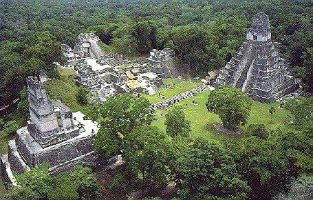
The ruins of Tikal are still splendid today.
The dynasty established at Tikal did much better than predecessors like Cerros. The dynasty's founder had the peculiar name of Yax Ehb' Xook, or First Scaffold Shark; Tikal's historians claimed he lived around 60 A.D., but because we only have two generations between him and the next important king, it is more likely he lived in the early third century (ca. 219-238). Perhaps Tikal really had a king in the first century, but his name and dynasty were forgotten by the time First Scaffold Shark came along. After him, there were two kings that left nothing but their names. Than came the first Maya king to give us any meaningful written information, Balam Ahau, or Scroll Jaguar Lord. Scroll Jaguar Lord raised two stellae, one of which was the first Maya artifact to have a date on it -- July 8, 292 A.D. That date marks the beginning of the Classic era, the golden age of Maya civilization. Therefore we will break off the Maya narrative here and come back after we look at what other ancient Americans were doing at the same time.
![]()
Teotihuacan, the City That History Forgot
Meanwhile, the Valley of Mexico produced an urban center even greater than those of the Zapotecs and Maya. This area in the heart of present-day Mexico has several natural advantages, making it perhaps the most pleasant place to live in the whole country. The basin is surrounded by mountains, and because it is elevated more than a mile above sea level, the temperature is much cooler than you'd expect for a place in the tropics. Thanks to more than eighty springs, and Lake Texcoco in the center, it was a well-watered basin. The part of the basin not covered by the lake was grassland, and the slopes of the mountains had pine and oak forests, full of small game: jackrabbits, turkeys, quail, deer, and small dogs. In fact, the only natural hazards one had to worry about were earthquakes (unstable ground under the lake tended to magnify and reverberate tremors in the area), and nearby volcanoes like Popocatepetl, Pico de Orizaba, and Iztaccihuatl.(27)
Civilization does not spring up in a place that can be described as paradise; when life is too easy, people are not motivated to build much, because they have got it made already. The best places to build a civilization are places where the climate is moderate, but there is a challenge to overcome, before people can live there comfortably. In the Valley of Mexico, the challenge was that Lake Texcoco was a brackish lake; salt from its waters contaminated the surrounding land. To make the land fit for agriculture, the farmers flushed it with fresh water from the springs. In the process they also turned swampland into rectangular garden plots called chinampas (“floating gardens”), which proved to be so fertile that they could grow as many as three crops per year. And work in the chinampas did not require much time--maybe just seven weeks out of the year--so the farmers could spend most of the year doing something else. The dramatic increase in yields from this irrigation project led to an equally dramatic increase in population. Because of that, the Valley of Mexico became the population center for all of Mesoamerica; the region's largest cities, especially Mexico City, have all been located here.
The first primitive settlements appeared in the Valley of Mexico around 1700 B.C. They were succeeded by a network of villages called the Tlatilco culture (1250-800 B.C.), which was strongly influenced by the Olmecs; most of the artifacts they left copied the Olmec style. Then came Cuicuilco, the first town in the valley, located within the city limits of modern Mexico City (about 700 B.C.-150 A.D.). Here the residents built a pyramid and made clay figurines, again in the Olmec style; at the city-state's peak, in 150 A.D., it was home to an estimated 20,000 people. But then suddenly an eruption from Xitle, the nearest volcano, buried the site and forced its abandonment.
The second community larger than a village in the valley was Teotihuacan, located thirty-three miles northeast of Cuicuilco. Founded around 200 B.C., it had 60,000 people by the time of Cuicuilco's destruction; no doubt a lot of the refugees from Cuicuilco went to Teotihuacan. Besides excellent farmland, this spot was blessed with rich deposits of obsidian (black volcanic glass) in the nearby hills. In a land where iron, steel and even bronze are unknown, obsidian is the best material for making mirrors and anything requiring a sharp blade, such as knives. This valuable resource made Teotihuacan the primary trading center of Mesoamerica. Finally, the residents of Teotihuacan set up hundreds of workshops, to mass produce pottery for export.
Dr. René Millon, the leader of the Teotihuacan Mapping Project, estimated in a 1973 paper that at its height, around 722 A.D., Teotihuacan had a population between 125,000 and 200,000 people.(28) This not only makes it the largest pre-Columbian city of all, but it also compares favorably with Old World urban centers. Until the Arabs built Baghdad, the only cities larger than Teotihuacan were Constantinople, Changan and Luoyang (China's twin capital cities), Ctesiphon (Persia's capital), and Alexandria; all other cities at the time, including Rome, were much smaller. Unfortunately we do not know what tribe or ethnic group lived there, because the Teotihuacanos had no writing and left no history.(29)
In two ways Teotihuacan was different from most major cities. First, it did not grow haphazardly over the ages, starting out as a few huts around a ceremonial center, with roads going out in every direction, and the builders tacking on new neighborhoods when the original one became too crowded. Instead, Teotihuacan's streets are laid out in a grid, covering eight square miles, a sign that like El Mirador, this was a planned city. Second, there was a lack of the specialization that other cities encourage; Teotihuacan was organized like an oversized village. Most of Teotihuacan's residents were at least part-time farmers, either growing their crops on garden-sized plots in the compounds where they lived(30), or leaving the city in the morning to work the fields and chinampas. Apparently the Teotihuacanos did not see an advantage in training a few people to perform an uncommon skill better than everybody else.
The main street in the city was a four-mile-long thoroughfare, running from north to south, called the “Avenue of the Dead” by the Aztecs. The Pyramid of the Sun sat on the east side of the Avenue; with a base nearly 700 on a side, and a height of just over 200 feet, it was nearly as wide, though less than half as high, as Egypt's Great Pyramid of Khufu. A lava cave has been found under the pyramid; that natural feature could have been what made the place a holy site in the beginning. Another pyramid, the Pyramid of the Moon, was at the Avenue's north end, while a temple dedicated to the feathered serpent god Quetzalcoatl, a huge mound called the Citadel, and the city's main marketplace were all at the Avenue's south end. Palaces and smaller temples were also found alongside the Avenue, which, contrary to its name, was bustling with activity in the city's heyday.
The principal god of the city was a goggled-eyed rain god, Tlaloc. Tlaloc didn't behave too badly, as ancient American deities go; his picture was everywhere, sometimes shown with naked figures dancing in his wet version of paradise. However, there was another god, Xipe Totec, who was worshiped with rites that were truly grim. Xipe Totec was the god of spring, rebirth, agriculture, vegetation, and several other things. Each year in March, to make sure that spring would begin on schedule, priests would put on the flayed skin of a sacrificed human, and wear it for twenty days. There also were human sacrifices at the dedication of a new temple; e.g., bones of the victims were buried under the corners of the pyramids (see footnote #3). Fortunately most religious festivals in the city were not bloody affairs; holidays were commonplace and usually celebrated with singing, dancing, the wearing of flamboyant headdresses, beating drums, blowing conch shells, and by drinking pulque (the fermented sap of the agave plant).
The size of Teotihuacan suggests that it received valuable goods--cloth and precious stones, perhaps, if not food--in the form of trade or tribute. It also must have attracted people from other areas, something cities always do when they are both political capitals and religious centers. After 400 A.D., enough Maya and Zapotecs moved into Teotihuacan to make two neighborhoods look like Tikal and Monte Alban, respectively; they had Maya and Zapotec-style pottery, architecture like you would see in homelands of those tribes, and even shaft graves (the Teotihuacanos usually cremated their dead). Conversely, at Monte Alban there is a relief sculpture showing a formal meeting between Zapotec nobles and a delegation from Teotihuacan, and around 400, Tikal produced an elaborate vase showing six visitors in Teotihuacano garb, being greeted by a Maya representative. These are signs that in the fifth century, Monte Alban and Tikal were at least trading partners of Teotihuacan, and more likely vassals or outright provinces. Two sites on the Gulf Coast, in the modern state of Veracruz, also show strong Teotihuacano influence: El Tajin (a Totonac city, inhabited from 600 A.D. to 1200 A.D.), and Cerro de las Mesas (an “epi-Olmec” site, inhabited from 600 B.C. To 900 A.D.). Another important satellite city was Cholula, located just east of the Valley of Mexico; it was a trade center that produced fine eggshell-thin pottery, and home to the largest pyramid in all the Americas (1,476 feet wide and 217 feet high), when completed around 700 A.D. Finally, in the Tuxtla Mountains overlooking the Pacific coast, Matacapán probably served as a way station for Teotihuacan's caravans. All this leads us to believe that Teotihuacan was the capital of a pre-literate empire, which ruled the central third of present-day Mexico, and maybe a little more. However, there were few soldiers, both in art and in real life, so we believe this was more of an economic empire than a military one. Perhaps we should call Teotihuacan and its satellite cities a cartel or a monopoly instead; like OPEC in our time, they had something everybody else wanted, but only traded with those who agreed to their terms.
It may surprise the reader to learn that the city which looked the most like Teotihuacan was not one of the cities mentioned in the previous paragraph, but Kaminaljuyu, the main Pre-Classic Maya city of central and southern Guatemala. Suddenly around 200 A.D., the original city was destroyed, and those who rebuilt it, unlike the original inhabitants, left no glyphic texts. From then until 900 A.D., the city was a miniature version of Teotihuacan. However, at a distance of 650 miles, the city was too far away to be under Teotihuacan's rule; what's more, to get there from Mexico, one had to pass through the Maya realm. Perhaps the answer to this puzzle is the Pipil, a Nahuatl Indian tribe that now lives in El Salvador. We know the Pipil migrated from Mexico at some point in the first millennium A.D.; they could have taken Kaminaljuyu in 200 A.D. and ruled it as their colony until Teotihuacan fell, before moving on to their present location.
This is the end of Part I. Click here to go to Part II.
FOOTNOTES
1. Sometimes, for the purpose of describing pre-Columbian cultures, central and southern Mexico are lumped together with most of the Central American countries (except Costa Rica and Panama), and called “Mesoamerica.”
2. Some will go further, claiming that visitors from outer space brought civilization to the New World. This is the so-called “ancient astronauts” theory; the way they see it, nobody on earth before modern times could have built structures like the pyramids, Tiahuanaco or the Nazca lines. Read “It Must Be The Mystery Factor” for my comments on that.
3. We normally think of Egypt when somebody mentions pyramids and mummies, but over the ages, Native Americans produced more of both. Does anybody want to claim that Native Americans civilized the Egyptians, instead of the other way around?
Incidentally, “pyramid” is not the best name for those great American monuments, though we will be using the term quite often. In both North and South America, they were more like the ziggurats of Mesopotamia than the Egyptian pyramids: a flight of steps up a terraced structure, with a chapel on top. Furthermore, most American pyramids were temples first and tombs second, while Egyptian pyramids were nothing but tombs. Some pyramids had sacrifices buried under a corner when they were dedicated, but only recently have we found royal burials in American pyramids,; the first to be discovered was the famous tomb of the Maya king Pacal. Unfortunately people have been calling these structures pyramids since at least the nineteenth century, so it is too late to change the term now.
4. “The mountains are too high to scale, the rivers are too wide to bridge. The progress of agriculture is stopped by impassable forests, and the harvests are destroyed by innumerable insects.”--H. T. Buckle, History of Civilization in England, London, Longmans, Green, 1868, Vol. I, pg. 106. Mr. Buckle was talking about Brazil, but that quote could describe the terrain almost anywhere in Latin America. Later on, when the Spanish colonies gain their independence, the rugged geography will be one of the reasons why they never formed a second United States of America.
5. Most of us think of Hawaii when asked where pineapples come from, but the pineapple is really native to Brazil. Other important crops originating in the New World included chocolate (from the Aztec xocolatl), avocadoes (ahuacatl), maize/corn, vanilla, tomatoes, peppers, eggplant, and peanuts. And see Chapters 11 through 13 of my European history for the effect the potato, a Peruvian root vegetable, had when introduced to Ireland. On the other hand, Native American grains like amaranth and quinoa did not catch on, and guayule, a Mexican desert shrub producing a latex sap that can be made into rubber, was never as popular as the Brazilian rubber tree.
6. We know horses and camels once lived in prehistoric America, because fossils of them have been found in American rocks, but they died out around the time of the ice age, and had to be reintroduced from the Old World later. Likewise, the mammoths became extinct long before anyone would have tried to domesticate them, so they will not play a role in the rise of ancient American civilizations.
7. The Incas did their accounting by tying knots in a bunch of strings called a quipu. For them quipus were a handy way to store information; a messenger running along the roads and rope bridges of the Incan Empire had no trouble carrying one, and it could be read by somebody at the destination. Because the Spaniards destroyed most quipus, seeing them as symbols of an idolatrous culture, and did not bother to learn how the natives could read them, we can't be sure today whether they truly contained information, or were just mnemonic devices, meant to stimulate the memory of the user. In today's South American Indian communities, quipus are still used, but they disagree on the meaning of the different knots and colors of string. For example, a yellow cord could represent gold or corn, depending on the distribution and shape of the knots; the difference may be clear to native tribes, but it isn't to us.
8. A by-product of the fish is the guano left on beach rocks by seabirds. Because bird poop makes an excellent fertilizer, a local industry developed around scraping the guano off the rocks and bagging it for export.
9. Those readers familiar with ancient Egyptian history will notice a similarity in how we break down that civilization's eras: Archaic, Old Kingdom, First Intermediate Period, Middle Kingdom, Second Intermediate Period, New Kingdom, Third Intermediate Period, Late Period, and the Greco-Roman era.
10. The weather cycle over the southeastern Pacific produces an El Nino event every three to seven years. Typically, an unusually high air pressure system just above the ocean warms the waters. If the temperature reaches six degrees Fahrenheit or more above normal, plankton in the ocean is killed off, and all the other sea creatures (birds and mammals as well as fish) must leave the region or starve. A really bad El Nino can ruin the fishing industry, like the one of 1973. And that's not all; the air pressure and heat alter weather patterns, causing severe floods on South America's coast, and droughts elsewhere. Conversely, low barometric pressure cools the ocean and produces a La Nina event, which isn't bad for the wildlife but otherwise can be catastrophic in just the opposite way (e.g., floods instead of droughts, and vice versa).
11. Where they got the cotton is another mystery. Chromosomal studies done in the late twentieth century suggest that New World cotton plants were hybrids, produced by cross-breeding a wild American strain with domesticated Asian cotton plants.
12. So far the only art objects found were some flutes made out of condor and pelican bones, and a few gourds with a godlike character painted on them. A few primitive quipus have been found, too (see footnote #7).
13. The oldest New World drug was coca, the raw form of cocaine found in the leaves of coca bushes. By burning seashells to produce lime, and chewing coca leaves with the lime, early Peruvians produced an alkaloid stimulant that kept them going; climbing around in the thin air of the Andes can wear anyone out quickly! Hallucinogenic drugs, like mescaline (derived from the San Pedro cactus), would come along later.
14. The Norte Chico rulers may have been nice guys, but there was a practical aspect to their behavior. Because the world wasn't crowded in those days (total world population was less than 1 percent of what it is now), there was far less competition for available supplies of food, water, gold, etc. And the small size of a typical tribe or village encouraged people to trade rather than fight, when they met other people. When you only have twelve to twenty folks in your group, the members are so interdependent on one another that the loss of just one member in a fight can be devastating. Eventually these meetings between groups became occasions to arrange marriages between young men and women, or to celebrate with religious ceremonies.
15. The early Mesoamericans did not trade metals because they did not know how to work with them until 800 A.D. They did not trade food either, so either they were well fed, or their communities all had the same foodstuffs.
16. Apparently the Maya and the Huastecs had a common ancestor, who lived in Guatemala. Around 1300 B.C. The Huastecs migrated to where we see them later on, in the modern Mexican states of Hidalgo, Veracruz, San Luis Potosi and Tamaulipas. The Maya get plenty of press for good reason, but you probably haven't heard much about the Huastecs. Like the Norte Chico culture in Peru, they interest us because they had an incomplete civilization; they built cities with pyramid-temples, and were known for fine pottery and music, but they went around without clothes most of the time. The other Mesoamerican tribes weren't heavily clothed either, due to the climate, but Huastec nudism, combined with a religion centered on sexuality, caused a prudish reaction that anyone in modern Western culture would recognize. The Aztecs called Huastec warriors “a screeching bunch of she-devils” and many tribes would describe someone they looked down upon by saying he was “as low as a Huastec.” After the Huastecs were conquered by Spain, they were converted to Catholicism, and forced to wear clothing.
17. A few scholars of the contrarian persuasion looked at the helmets and suggested that the heads represented ball players, rather than rulers; the Olmecs played a ball game we will be hearing more about later on. Others, like Ivan Van Sertima, thought the heads looked African, and used them to propose that the ancestors of the Olmecs were Africans who crossed the Atlantic. However, it appears that both were wrong, for a practical reason. The quarry where the Olmecs carved the heads was fifty miles from San Lorenzo, and they could have towed them on riverborne rafts for part of the way, but they had neither wheels nor draft animals to make the task of dragging them over land easier. Therefore it would have made sense to give the heads rounded and flattened features, to reduce the chance of them getting damaged in transit. They may have even rolled the stone heads part of the way!
18. The Maya pegged the starting date for their “Long Count” calendar at August 11, 3114 B.C. Read my essay “Doomsday in 2012?” to see what I think they meant by that.
19. For Mesoamerican numerals, a shell or oval meant zero, a dot meant one, and a line meant five. To represent the numbers in-between, they used multiple dots and lines; for example, they drew two lines and two dots to show the number twelve (5 + 5 + 1 + 1). Because ancient Americans counted on their toes as well as their fingers, they used a base-20 system. Also impressive is the fact that they knew the concept of zero; in the Old World at this time, only the mathematicians of India saw the advantages in having a numeral to represent nothing.
20. The Chavin culture was the first one in South America to show us a ruling class of priest-kings. If the Norte Chico had a ruling class, they left no pictures or any other signs of it.
21. The hippies of the twentieth century used LSD to get the same ideas. In hippie slang, people who did that were called “trippers!” Here is part of a Paracas cloak, showing repeated images of the ecstatic shaman.
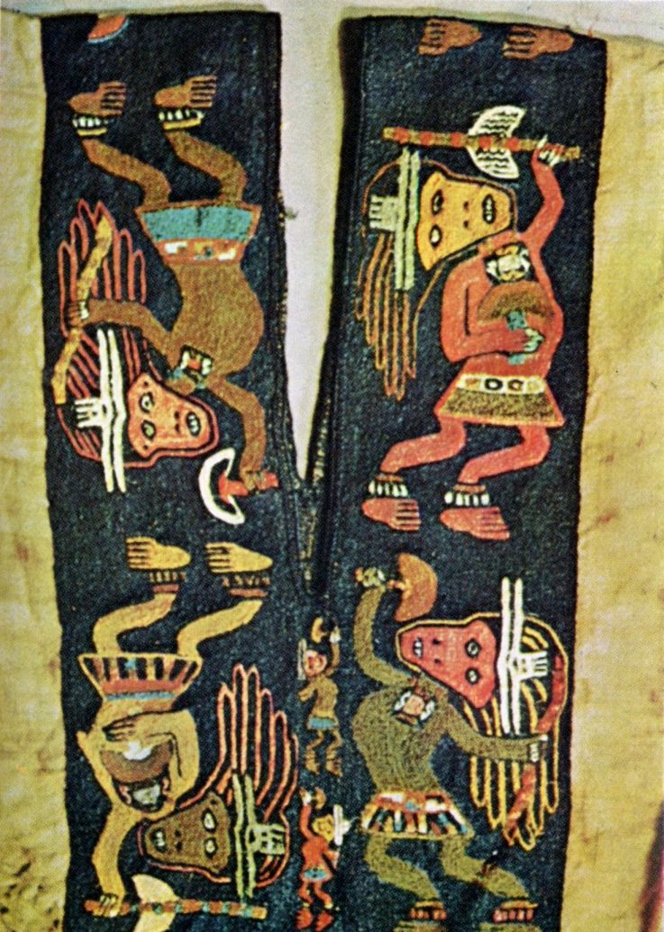
22. We already mentioned the Long Count calendar in footnote #18. Mesoamericans also had a “Short Count” calendar that only had 260 days in it (13 months of 20 days each). Once every 52 of our years, the Long Count and Short Count years began on the same day, and then a new cycle of Short Count years would begin. Mesoamericans treated the Short Count cycle the same way we treat centuries; because the life expectancy was shorter than 52 years, most Mesoamericans did not live through more than one cycle. Therefore if they were in a hurry, they would only write the short count date. We do the same thing when discussing anything besides history; that is why we feared our computers would crash when 1999 became 2000 (the Y2K crisis). For example, the shorthand way to write the second day of the second month, in the eleventh year, is “2/2/11”; the reader has to decide whether the year meant is 2011, 1911, 1511, or 2111.
23. The adjective “Mayan” is not as popular as it used to be. It is still OK to refer to the “Mayan” language, but for anything else having to do with this people or their civilization, “Maya” is preferred.
24. In other times and places, wars are caused when a group of people wanted land, or access to a valuable resource; sometimes leaders start wars to spread a religion or ideology, or to gain personal glory and status. Among the Maya, these were factors, but the most important was the need to get sacrificial victims for their religious ceremonies; understandably, few of their own subjects were willing to die for the sake of their cities.
25. Archaeologists used to believe that the Maya just practiced slash-and-burn agriculture, but that would not have produced enough food to feed a city like El Mirador. More recently they have discovered that the Maya created raised fields, by draining swamps and flood plains and heaping the soil dug from the drainage ditches into mounds several feet higher than the water level. This was quite labor-intensive, because the workers had only stone-tipped adzes and hoes to do the digging, but the bigger yields made it worth the effort; the tropical climate also allowed farmers to grow crops all year round. And the volcanoes in the region (see footnote #27) would have increased the fertility of the soil, every time they dropped ash on it. Finally, the Maya were familiar with irrigation, and practiced it in areas that did not get enough rainfall.
Recently 810 squares miles of the Petén were scanned from the air, using LIDAR (laser-based radar). The researchers behind the project announced the results in 2018; under the covering jungle they detected 60,000 man-made structures, including houses, defensive works, and pyramids. This suggests that the lowlands once supported two to three times as many people as we thought, perhaps as many as ten million when the Maya civilization peaked. It also looks like agriculture was practiced on a massive scale to feed this population; in some areas, as much as 95 percent of the arable land was cultivated.
26. Mt. Ilopango erupted again in 535 A.D. It is not known if this had anything to do with the worldwide drop in temperatures that happened in the same year (the so-called 535 A.D. catastrophe).
27. There are more than twenty volcanoes in central and southern Mexico, a zone geologists call the Trans-Mexican Volcanic Belt (TMVB). The youngest is Paracutin, which in 1943 sprang out of a farmer's cornfield in the state of Michoacan. By the time Paracutin stopped erupting in 1952, it had grown nearly 1,400 feet.
28. Our current population estimates put anywhere from six to twelve million people in the Americas at this time, of which half of them lived in Mexico, Guatemala, Belize and Honduras.
29. The Totonacs, an Indian tribe living in the states of Veracruz, Hidalgo and Puebla, insist that Teotihuacan was one of their cities; the Aztecs simply accepted that claim and passed it on to us. We don't even know what the city's original name was, and have to use the name the Aztecs gave it, meaning “Place of the Gods.” When the Aztecs discovered it, Teotihuacan was in ruins, having been abandoned centuries earlier, and because it was even larger than their own capital, Tenochtitlan, the Aztecs thought the gods were born here, and held some religious ceremonies on the site.
30. Teotihuacan did not have single-family homes, but it had more than 2,200 apartment complexes that could each hold as many as a hundred people.
Support this site!
![]()
PAGE NAVIGATOR
A History of Latin America and the Caribbean
|
Other History Papers |
Beyond History
|