
|
| The Xenophile Historian |
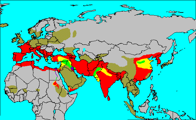
Map 1: The spread of civilization in thousand-year steps. The purple areas became civilized by 3000 B.C. Civilization spread to the green areas by 2000 B.C., yellow by 1000 B.C., red by 1 A.D., and brown by 1000 A.D. The rest of the world (grey) has either acquired civilization since 1000 A.D., or is not yet civilized.
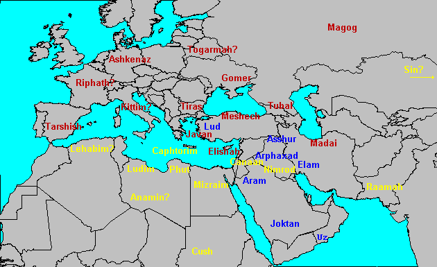
Map 2: The Table of Nations. Blue = descendants of Shem, Yellow = descendants of Ham, Dark Red = descendants of Japheth.
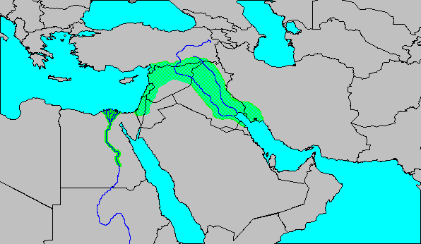
Map 3: The Middle East, around 3000 B.C. The Fertile Crescent and the settled part of the Nile Valley are shown in green. The northern shore of the Persian Gulf was at least 100 miles farther inland than it is now, and much of northern (lower) Egypt was underwater, but details are very sketchy on both.
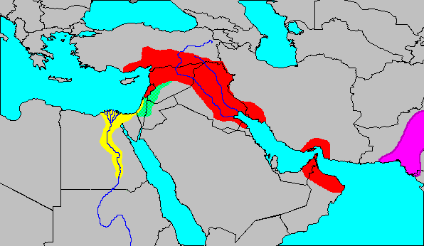
Map 4: The Middle East, about 2300 B.C. Shown here are the empire of Sargon I (red), VI-dynasty Egypt (yellow), and the Indus valley civilization (purple).
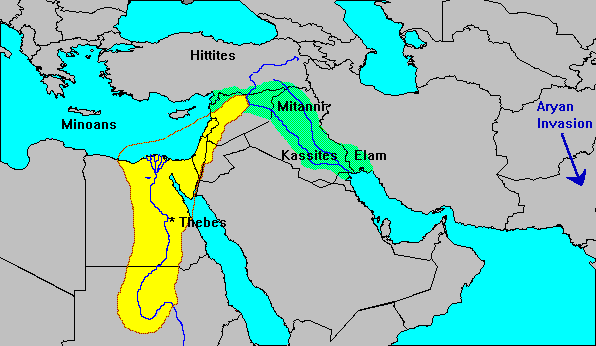
Map 5: Egypt (yellow area) under Thutmose III, traditional date 1450 B.C. The names of some other important nations from that time are superimposed over their homelands.
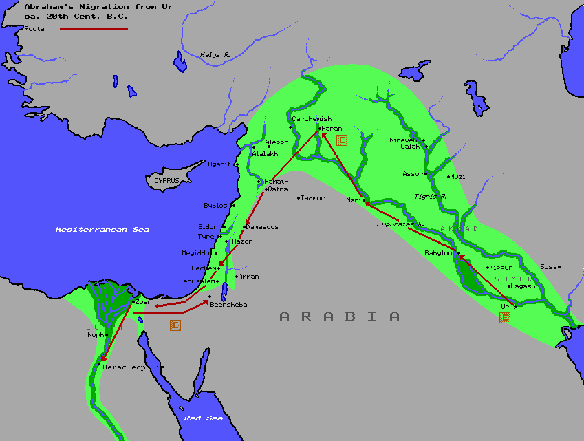
Map 6: Abraham�s travels across the Fertile Crescent.
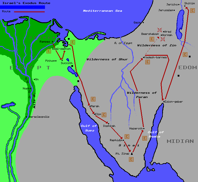
Map 7: The generally accepted route of the Exodus.
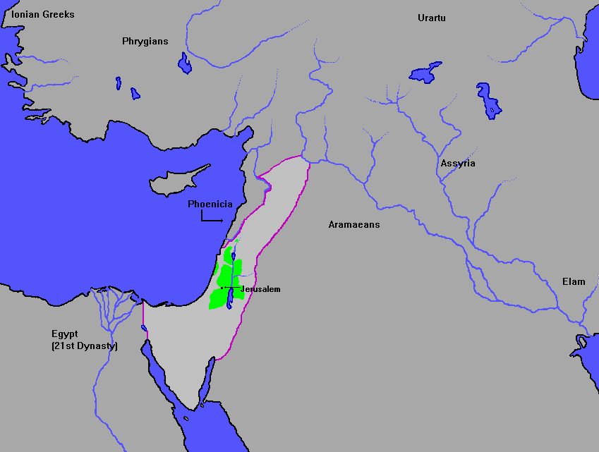
Map 8: Israel between 1400 and 930 B.C. The green area is where the Israelites were settled during the time of the Judges; the purple line marks the border of the empire of David and Solomon.
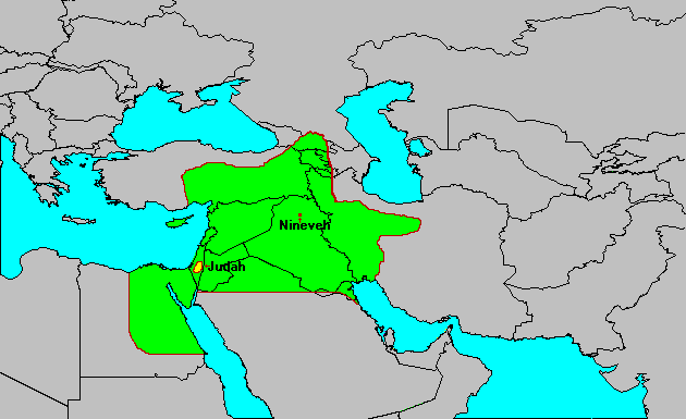
Map 9: The Assyrian Empire, about 670 B.C. Note that Judah was surrounded and forced to pay tribute, but it never became a part of Assyria.
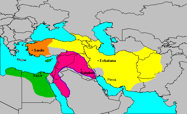
Map 10: The age of the four kingdoms, 612-550 B.C. The Babylonian Empire (pink) was the strongest and most impressive, but Lydia (orange), Media (yellow) and 26th-dynasty Egypt (green) also enjoyed good times. The capital of each is marked.
Map 11: The Hellenistic world, 300 B.C. Alexander the Great�s empire contained everything within the red lines. A generation later, four of his generals ruled pieces of it: Ptolemy (dark green portion), Seleucus (yellow), Lysimachus (purple), and Cassander (pink).
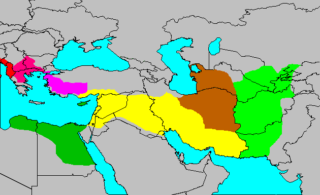
Map 12: The Hellenistic world, 167 B.C. When the Maccabees began their revolt in Judaea (asterisk), three states from the previous map were still around--Macedonia (pink), the Ptolemaic Kingdom (dark green), and the Seleucid Kingdom (yellow). They now face serious challenges from Bactria (light green), Parthia (brown), Pergamun (violet) and Rome (red).
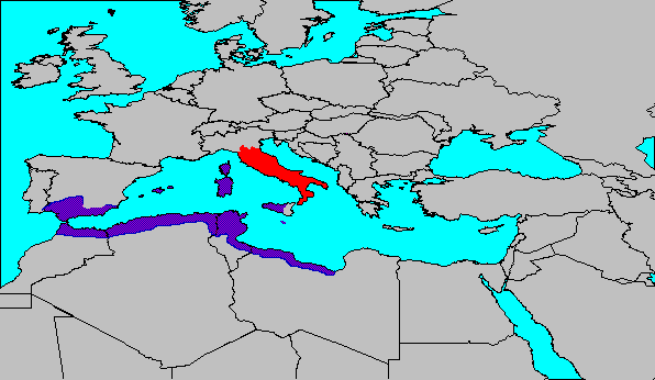
Map 13: Rome (red) and Carthage (purple) before the Punic Wars.
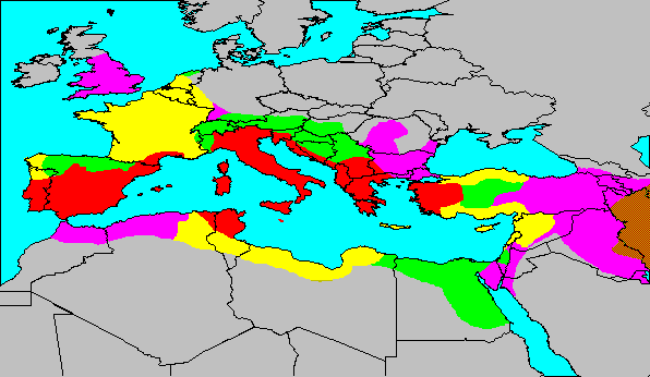
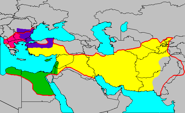
Map 14: The growth of the Roman Empire. Rome conquered the red areas by 133 B.C., the yellow areas by 44 B.C., the green areas by 14 A.D., and the violet areas by 117 A.D. To the east was Rome�s civilized opponent, the Parthian Empire (brown).
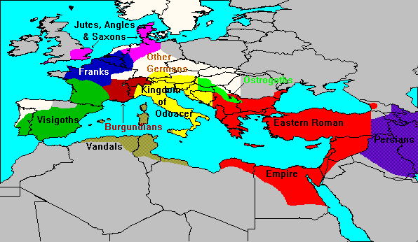
Map 15: Europe, 486 A.D. Ten years after the fall of Rome, the last general claiming to be a Western Roman emperor was killed by the barbarians.
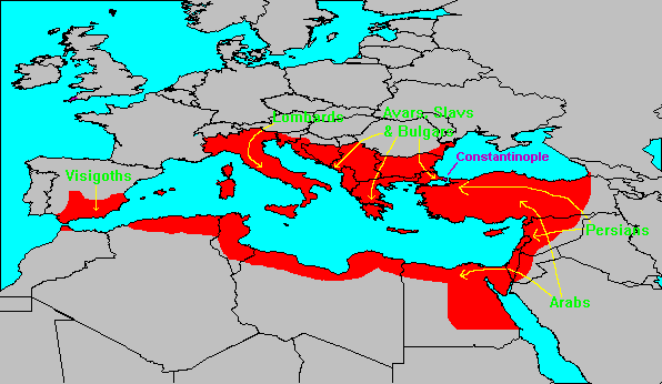
Map 16: The Eastern Roman Empire at its height (565 A.D.), and the invaders who wrecked it soon after that.
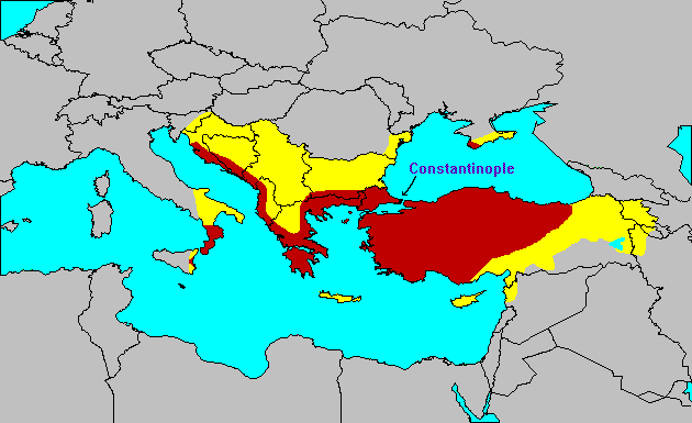
Map 17: The Byzantine Empire saw considerable recovery under the Macedonian Dynasty. By the mid-ninth century it was reduced to the dark red areas on this map; the yellow areas were reconquered between 867 and 1045.
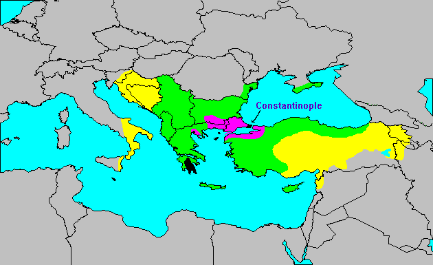
Map 18: Byzantium�s last four hundred years. The yellow areas were lost in the late 11th century, the green areas were lost in the 12th and 13th centuries, and the purple areas were lost in the 14th century. The remaining bits and pieces (black) were taken by the Ottoman Turks, culminating with the capture of Constantinople in 1453.
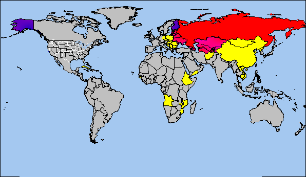
Map 19: The breakup of the Soviet Union in 1991 left Russia (red) with little land besides what it had in the mid-17th century. The other former Soviet republics are pink; the purple areas were part of the Russian Empire, but not the Soviet Union. Yellow marks other countries with communist governments, most of which were Soviet satellite states between 1945 and 1990.
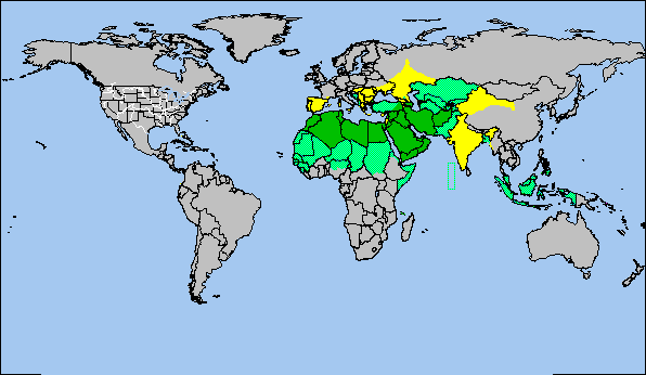
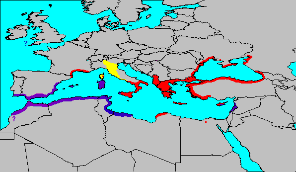
Map 20: The Islamic world. Dark green areas were conquered/converted by 700 A.D., light green areas after 700. The yellow countries were once under Islamic rule, but are not today.
Map 21: Charlemagne�s empire, 814 A.D.

Map 22: The Holy Roman Empire, under the Hohenstaufen kings (1125-1250).
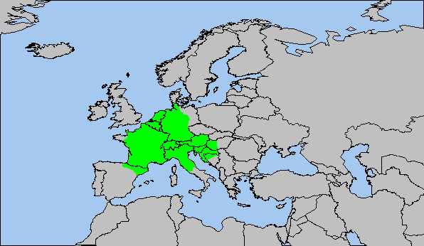
Map 23: Germany today (yellow), and the colonies it held in 1914 (brown). The steel-blue areas were occupied by Germany in 1942, at the height of Adolf Hitler�s power.
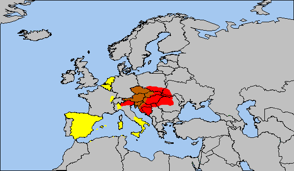
Map 24: The brown area marks Austria�s core territory in the 16th-17th centuries. Charles V inherited the yellow areas, and bequeathed them to his Spanish son, Philip II. Together the brown and red mark the Austro-Hungarian Empire (late 19th century).
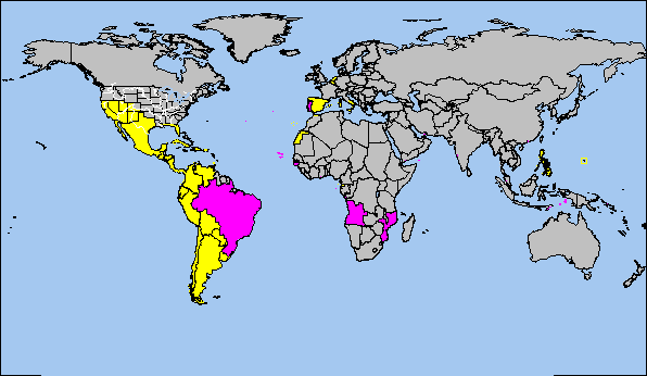
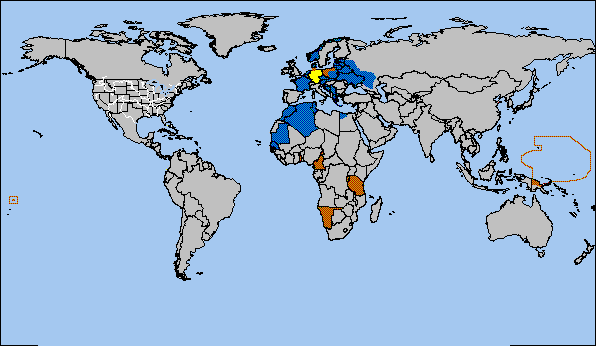
Map 25: The Spanish (yellow) and Portuguese (purple) colonial empires. Most of their territories were held in the 16th century.

Map 26: The French (dark blue) and Italian (red) empires in the late 1930s.
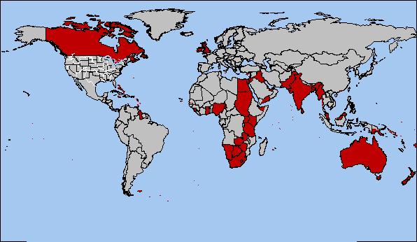
Map 27: The British Empire between World War I and II.
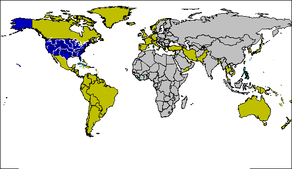
Map 28: The United States of America (dark blue), former territories it ruled (aqua), and its allies during the Cold War (gold).
Map 29: Greece and her colonies (red) in the mid-sixth century B.C. Also shown are the two main rivals of Greece, the Phoenicians (purple) and the Etruscans (yellow).
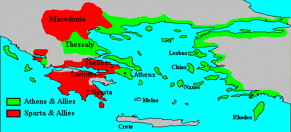
Map 30: The Peloponnesian War. Nearly all of Greece was polarized between two alliances.
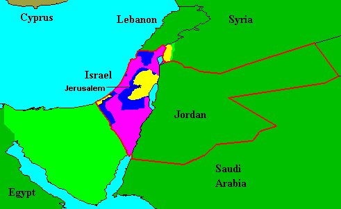
Map 31: Israel in the twentieth century. The nearest Arab states are shown in dark green; the red line marks the borders of the Palestine Mandate between 1918 and 1948. The purple areas were given to Israel by the UN in 1947; the dark blue areas were conquered in the 1948 war. The yellow and light green areas were added in the Six Day War of 1967; the light green (Sinai and a small part of the Golan heights) was returned between 1974 and 1982. From this map you can see how small Israel is in comparison to her neighbors, and that "land for peace" proposals are a fantasy; the Arabs have more land, while Israel has more peace!
Support this site!