 | The Xenophile Historian |

 |
 |
 |
 |
 |
 |
 |
 |
 |
 |
 |
 |
 |
 |
 |
 |
 |
 |
 |
 |
 |
 |
 |
 |
 |
 |
 |
 |
 |
 |
 |
 |
 |
 |
 |
 |
 |
 |
 |
 |
 |
 |
 |
 |
 |
 |
 |
 |
 |
 |
 |
 |
 |
 |
A History of Africa
Chapter 1: PREHISTORIC AFRICA
Before 2800 B.C.
This chapter covers the following topics:
| Introduction | |
| When the Sahara Was Green | |
| Most Ancient Egypt | |
| The Real Scorpion King(s) | |
| In the Rest of Africa | |
| Go to Page Navigator |
Introduction
For many centuries Africa and its people seemed strange to the rest of the world. Generations of traders came by ship or by caravan, to purchase Africa's wealth in gold, ivory, and human beings, but their reports produced more mysteries than they solved. Where did the Africans come from? Why did they look so different from other men, and have different customs? Eventually the Europeans concluded that the Africans were savages, inferior human beings, and they couldn't help being the way they are.
That answer lasted until most African nations achieved their independence in the middle of the twentieth century. Since that time scholars have re-discovered Africa's history and heritage. The so-called "dark continent," it turns out, is not just a land of endless savagery and chaos. Its people have a history of their own, and have created cultures, nations, and art that often compare favorably to what other cultures have produced.
Africa can also be difficult to understand because it is such a diverse place. The local terrain, climate and ecology vary tremendously from one place to another. For example, near the mouth of the Red Sea is a lowland called the Danakil Depression, a desert of fearsome heat, decorated with volcanoes and strange rock formations; it looks a lot like Mordor, the land of evil in J.R.R. Tolkien's "The Lord of the Rings." However, the Danakil Depression is also part of the Great Rift Valley, the same geological feature that contains Africa's highest mountains and the much-more-pleasant East African lakes. The people of Africa are also more diverse, in race, tribe and culture, than on any other continent. Most likely this happened as a combination of isolation and the need to adapt to widely varying conditions. No culture in Africa can be cited as typical of the whole continent.(1)
Most Africans were, and still are, descendants of Ham, one of Noah's three sons. They all migrated out of the Middle East before 3000 B.C., following more than one path. The families of Mizraim and Phut (two of Ham's sons) took the most direct route, across the Sinai peninsula into Egypt and from there they followed the Mediterranean coast all the way to Morocco. Today they make up the North African peoples, the two largest groups being the Egyptians and the Berbers (the latter include the Tuareg, the nomads of the deep Sahara). The Berbers call themselves Imazighen, meaning noble or free men; the name we use comes from the Latin Barbari, or barbarians. Linguists lump all North African groups together under the name Hamites.
South of the "Hamite" realm a different world existed. The people living here came from another son of Ham, Cush, and they got there by traversing Arabia and crossing the Red Sea to Ethiopia, presumably at the Red Sea's narrowest point, the Bab el Mandeb. Moving both south and west, individual families and tribes got separated from their kinsmen. Isolation caused genetic drift to set in, and the Cushites differentiated into four distinct racial groups: the Bantus, Nilotics, Pygmies and Bushmen.
Of those four groups the Bantus have been by far the most successful. At the beginning of history they lived in the forest and bush country of West Africa, from Cape Verde to the Cameroon mts. They are the Africans most of us are familiar with: tall, black-skinned and broad-nosed. Around 1 A.D. they started to migrate into the rest of sub-Saharan Africa; this is arguably the most important event in African history.
The Nilotics or Nilo-Saharans are also tall and black but thinner in both body and face. At first they only lived in the middle third of the Nile valley (modern Sudan), but later they spread south to the equator and as far west as Lake Chad. Today they are found all along the Sahara's southeastern fringe; modern examples of Nilotics include the Somalis, Nubians, Masai and Tutsi (also called Watusi).
The Pygmies live in the rain forests of the Congo (formerly the Zaire) basin. They really are small, averaging 4' 6" in height; their skin is brown to black, their noses are broad and their hair is scanty. The Bushmen are just a little bit bigger (averaging 5' 2"), with yellow-brown skin and hair that grows in tufts, creating a "peppercorn" look. They speak the world's most unusual languages, using clicking sounds along with vowels and consonants. Like the Pygmies, the Bushmen have been largely displaced from their lands by the Bantu migrations. Today the Bushmen are confined to the Kalahari desert in the southwest, but at one point they had all of eastern and southern Africa to themselves.
Finally mention should be made of two ethnic sub-groups that are special cases. The Hottentots of Namibia are a mixture of Bushmen and some other race, presumably the Bantu. Today's Ethiopians (called Cushites by anthropologists) have a number of Semitic features, such as long noses and wavy hair, because more than one Arab tribe came across the Red Sea in the first millennium B.C. However, they are darker than the Semites or Hamites found elsewhere, no doubt because of interbreeding with their black neighbors.
Though wetter than the Sahara, very little of sub-Saharan Africa is hospitable to man. The grasslands are not lush American-style prairies, but tropical savannas. Baked for six months by the sun, then leached by six months of heavy rains, the topsoil is too poor to grow most crops. No long mountain ranges rise in Africa to wring moisture reliably from passing air masses. The mountains that exist have an enticing green color, but are covered with scrub and thorn instead of grass.
Rivers meander without going in a straight direction anywhere, and because most of Africa is on a plateau, they crash in tremendous waterfalls that interrupt navigation. Only the Nile and the Niger have long, navigable stretches through open (non-forested) countryside, which is why Africa's largest kingdoms have appeared on the banks of those rivers. In some places the plateau and clay soil combine to produce a feature almost never seen elsewhere--inland deltas. Here rivers break up to form several smaller streams, which meander for a while before coming back together into one river. Examples of inland deltas include the upper Niger, between Jenné and Timbuktu in Mali; the Sudd in South Sudan; and the Okavango delta in northern Botswana. A similar environment exists on Lake Chad, where masses of vegetation break off to form floating islands, regularly changing the outline of that lake's shore. Only the inland delta on the Niger has been fertile enough to feed a civilization (see Chapters 4 & 5). By contrast, the Sudd is a swamp on the White Nile that no one could pass through for most of history. Like Lake Chad, the Sudd has mats of vegetation floating on its surface. Mapping the Sudd and Lake Chad is pointless, because those mats change shape constantly, making maps inaccurate almost as soon as they are drawn. Remarkably, today some people build homes on the mats in the Sudd, though the only way you can get to them is by boat. This goes to show that if life is possible in a place, someone is going to live there! Finally, the Okavango attracts many animals, because the land around it is fertile, but it has never had a large enough community of people to start a civilization.
Heat never goes away, because Africa straddles the equator and is contained between 38o north and south latitude, making it the most centrally located of all continents. Relief only comes in the higher altitudes of the eastern and southern plateaus and on parts of the west coast, where currents transport seawater from cooler regions.
Overall, rainfall patterns reveal extreme contrasts. The jungles are a dense and dank world where the sun rarely shines, deluged with two rainy seasons totaling eight or more feet per year and once described as a "glittering equatorial slum [where] huge trees jostle one another for room to live." The rest of the continent has a single wet season, which may deliver insufficient rainfall to some areas and skip others entirely. Two thirds of Africa loses more water to evaporation than is gained from rain. One of the hardest hit areas in recent years is the Sahel, the belt of grassland immediately south of the Sahara; here the water table is steadily dropping, requiring the digging of deeper wells, and the desert expands further south every year. Often man has contributed to the desertification process, by destroying the vegetation through overgrazing or the burning down of wooded areas.
Now is there a country in Africa where these different environments meet? Yes, and that country is Cameroon, so if you can only visit one country on the continent, Cameroon is where you'll see the most variety. To start with, like most African countries, Cameroon's borders were drawn by Europeans, and they get really absurd here, because they were changed more than once. First, the whole territory was a German colony (spelled Kamerun) in the late nineteenth-early twentieth centuries. Then after World War I most of it went to France, except for two pieces in the west that went to the British. Finally, after the French zone became independent, Britain merged one of its territories with it, and gave the other one to Nigeria. And that is how Cameroon's present-day borders were established.
So what biospheres are represented in Cameroon? Everything you can find in Africa, except for the extremely dry desert of the Sahara, and the temperate zone on the southern end of the continent. First, the narrow, northern tip of the country reaches into the semi-arid Sahel region, and touches Lake Chad. Below this is a slighty wetter zone with grass and some trees, called the Guinea Savanna. To the southeast is jungle; if you watched "Tarzan" movies, this what you expect Africa will look like. There is plenty of wildlife here, and this zone gets the highest rainfall in Africa, up to 400 inches per year. In the west, near the Nigerian border, is a mountain range; the highest mountain, Mt. Cameroon (13,435 feet high), is an active volcano. The islands off this part of the African coast -- Bioko, Pr�ncipe, S�o Tom� and Annob�n -- were formed by the same volcanic activity that powers Mt. Cameroon. On top of all this, Mt. Cameroon is tall enough to sometimes get snow on the peak, even though the whole country is close to the equator.
Finally we need to mention the deadly diseases and parasites, which have killed many men and even more livestock, making herding impossible in some locations. The highlands of Ethiopia, Kenya and Tanzania, for example, are cool enough and well-watered enough to allow agriculture and herding, but they are also infested with the tsetse fly, a bloodsucking insect that carries the dreaded sleeping sickness. However, the fly doesn't bother antelopes much, so antelope herds became carriers of the disease, infecting human hunters who pursued them. As a result, the tsetse fly saved Africa's wildlife from being hunted to extinction; on much of the savanna the lion, and not man, remained at the top of the food chain. Other deadly diseases are malaria and yellow fever. Many of the natives are protected from malaria by sickle cell anemia, a hereditary disease that makes red blood cells unappetizing to the malaria parasite; unfortunately sickle cell anemia can also be fatal, if the subject inherits it from both parents.
But the heirs of Cush overcame all these obstacles. They learned how to live in their inhospitable land, how to grow crops(2), and how to raise cattle. In the second millennium B.C. they started forging iron; they might have learned this trick from the Middle East, but they did it so early that it is also possible that they discovered the secrets to smelting ores by themselves. Finally their tribes turned into cities and nations. Their progress took longer than it did on other continents, because the black African found it a constant struggle to stay alive at the same time, but he did progress in the long run.
The Countries of Modern Africa
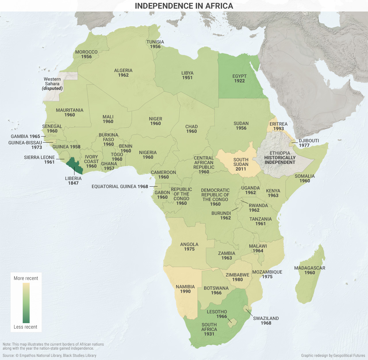
Bounded by the Atlantic Ocean to the west, the Indian Ocean to the east, and the Mediterranean Sea to the north, the African continent and surrounding islands are divided into more than fifty countries. After World War II many African territories began to fight for their independence from European colonization. The borders of many modern African nations reflect the colonial boundaries. The date on each territory indicates when it achieved independence. There are also two special cases. The blank territory below Morocco was called the Western or Spanish Sahara before 1976. It has been part of Morocco since then, but some countries do not recognize this annexation. As for Ethiopia, it was not occupied by a foreign power (Italy) until 1935, and then the Italians were expelled just six years later.
![]()
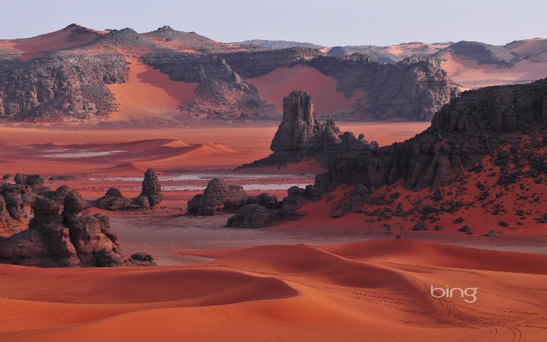
When the Sahara Was Green
Civilized and not-so civilized people have lived in Africa since prehistoric times; evolutionists, in fact, claim it is the birthplace of the human species.(3) When the first humans arrived, they found a very different Africa from the Africa of today. North America and Eurasia were in the grip of the Ice Age, and Africa's climate also changed with the advancing/receding of the polar icecaps, alternating between wet and dry cycles. Most of what is now the Sahara Desert was savanna; mountains held trees and grass, and fish and game were plentiful. Many tribes (first hunters, later farmers and herdsmen) roamed this landscape.
But the Sahara did not remain a garden when the Ice Age ended. Wind patterns changed as the world grew warmer. The monsoon winds stopped blowing from the south, and without their rains, North Africa began to dry up. The rivers got smaller and disappeared; sand replaced grass; the forests died. The game and fish went away, and so did the people. The drying out began in Egypt, most likely during the early to mid-fourth millennium B.C.; as the land began to bake in the sun, the people living there gathered in the only places where water remained, the oases and the the Nile valley. Spreading west, the process was complete sometime in the second millennium B.C.
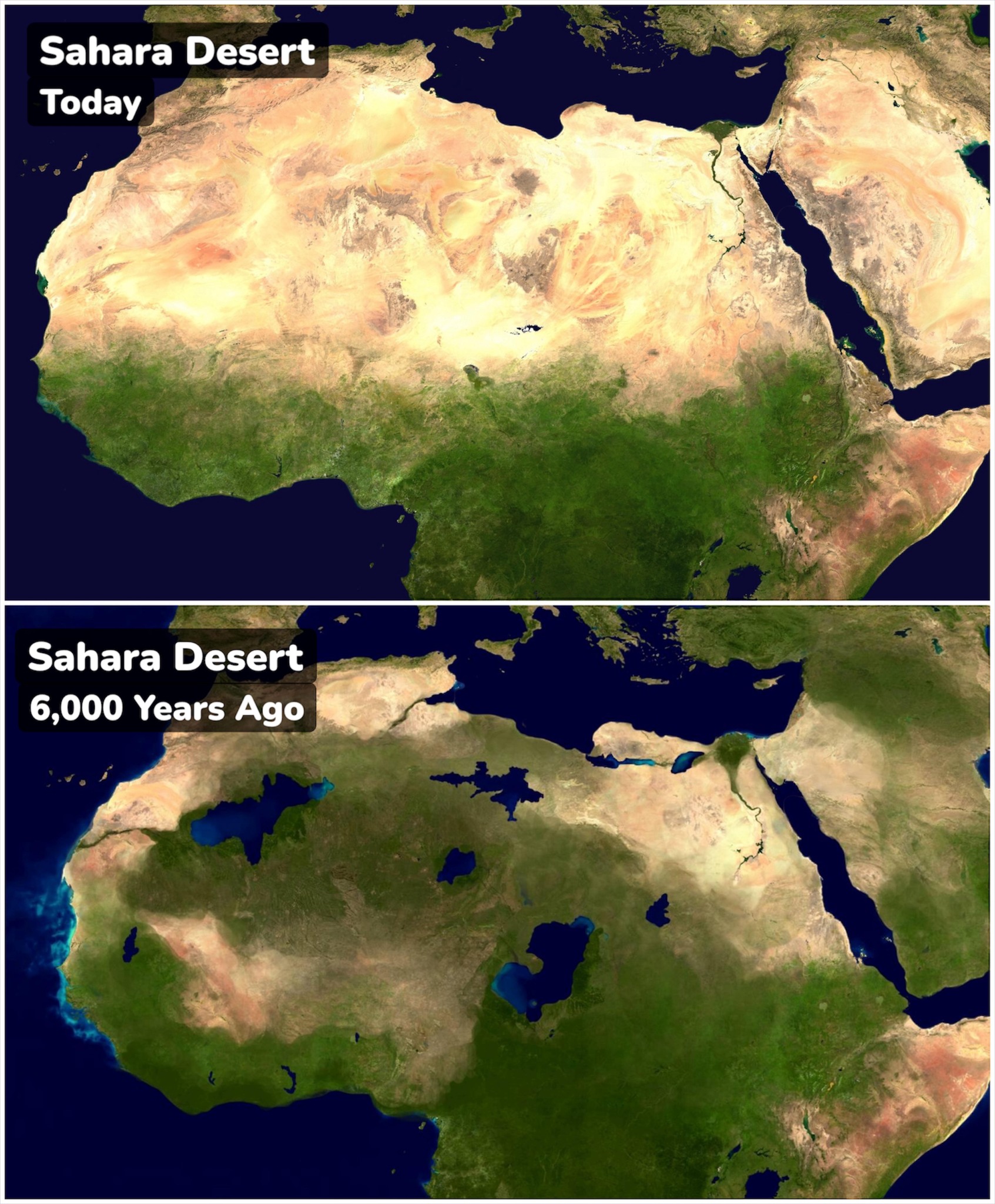
The middle of the Sahara contained an inland fresh water sea, which at one point covered 154,000 square miles and was 570 feet deep. We call it a "sea" because it was even larger than the Caspian Sea, the largest lake in today's world. When the climate became more arid, the "Sahara Sea" shrank and split into two large lakes, Lake Bodele and Lake Chad. Lake Bodele was larger, but it eventually dried out, leaving Lake Chad as the only body of water in the Sahara, aside from the oases.
The recent history of Lake Chad is one of the environmental disasters of the modern world. For most of recorded history, Lake Chad covered about 15,000 square miles. Like most of Africa, the lands surrounding the lake were under European rule in the early twentieth century. Not much happened in the area during that time. Then in 1960, the Europeans granted independence (see Chapter 8), and those lands became four new nations: Chad, Niger, Nigeria and Cameroon. Naturally, these countries wanted to improve the livelihood of their people. To make sure the people had enough water, and to irrigate farms, they drew it from the rivers flowing into Lake Chad. Because of this, and because of the drought that afflicted the Sahel during the late twentieth century, the lake shrank. At the smallest point, in 1998, Lake Chad had been reduced to only 778 square miles. Thanks to more rainfall in recent years, and to conservation efforts, the lake has seen a partial recovery, but today it still covers less than 2,500 square miles. The lake needs to be saved because these days, 40 million people depend on it for its water and fish.
Across the Sahara, there were some wet phases around 750 B.C. and 500 A.D., when the climate briefly changed in the other direction, but most of the time rain evaporated before it even hit the ground. Salt, leached out of the rocks by evaporating marshes and ponds, formed deposits that would some day become the Sahara's most valuable resource, and wind erosion wore down quartz-bearing rocks into the ever-present sand. No longer a home or a highway, the Sahara became the world's largest desert, a barrier that few dared to cross.(4)
On a plateau named Tassili-n-Ajer in southern Algeria, the natives produced 15,000 superb rock paintings. In 1956 and 1957 a French explorer, Henri Lhote, traveled to Tassili, studied the paintings, and brought back copies of 800 of them; this is the most complete collection of prehistoric art to be found anywhere. All sorts of animals are portrayed here, from elephants and giraffes to rabbits and cattle, showing us that the land could once support much more wildlife than it does today. Scholars have classified the paintings into four rough time periods, each named after the most common art subject:
- The Hunter era (before 4000 B.C.?)
- The Herder era (4000 to 1500 B.C.)
- The Horse era (1500 to 600 B.C.)
- The Camel era (600 B.C. and afterwards)
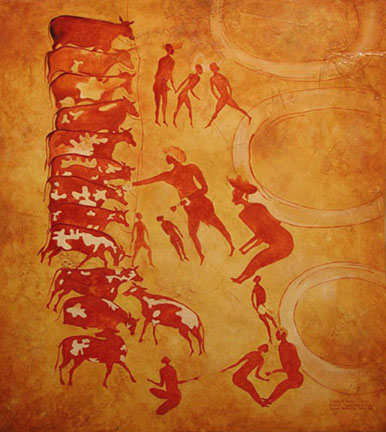
An example of Saharan rock art, showing herdsmen counting their cattle.
These paintings show not only how the locals progressed from hunting to the herding of animals, but also how the increasing dryness of the landscape caused the wildlife to change; the camel, for example, is first mentioned in ancient texts as living in Africa in 46 B.C.
Who were these people? Because the Tassili paintings stretch across millennia, several cultures are represented. Most represent scenes that would be familiar to tribes in other parts of Africa, while a few show individuals with costumes and hairstyles that look remarkably modern. There was some contact with the outside world, but not much; one painting featured four ibis-headed humans, looking very much like the Egyptian god Thoth, while classical writers like Herodotus mentioned tribes like the Garamantes living in the interior of Libya(5), but knew very little about them. We are confident, though, in asserting that the increasing dryness of the Sahara is what finally drove them away. A few probably stayed nearby, becoming the ancestors of the Tuareg, while others moved north, becoming the Berbers of Morocco, Algeria and Tunisia. Here the densely forested Atlas mountains, which reach as high as 13,000 feet, halted the spreading of the desert, allowing a relatively mild climate along the Mediterranean shore.(6) Still others went south, to join the tribes already living there. Here they found themselves isolated from the rest of humanity, surrounded by oceans on three sides and desert on the fourth. Indeed, until the invention of ocean-crossing ships and the opening of trade routes across the Sahara, the only easy path into and out of sub-Saharan Africa was via the Nile valley, and very few travelers were willing to go that way. Thus, Africans were largely left out of the sharing of ideas and technologies that went on between European and Asian civilizations, further limiting their progress. Eventually, much of the outside world forgot about Africa, and came to see it as a land without a past. When Europeans discovered the ruins of impressive cities like Zimbabwe, they assumed that such structures could never have been built by blacks.(7) For much or the late nineteenth and early twentieth centuries, theories were floated around about a lost white colony on the continent, most likely planted by King Solomon or the Queen of Sheba. It took decades of work before non-African scholars were persuaded that most of the artifacts found in Africa came from the indigenous population. Only then did it become possible for outsiders to view Africa and its history the way its inhabitants view them.
![]()
Most Ancient Egypt
Five thousand years ago most of the world's people made a living by hunting, fishing, or by gathering fruits and roots; we call this the paleolithic or "Old Stone Age." The shift from the paleolithic to the neolithic, or New Stone Age, took place when mankind switched to food production: the sowing and reaping of edible plants and the herding of domesticated animals. The Middle East, however, has been neolithic at least since Noah's Flood; here we find communities growing wheat and barley and tending sheep goats, pigs and cattle at a very early date, before the invention of writing. Where this took place more food became available, allowing for a population increase, and the growth of cities.
Most of the communities that took up cultivation became entirely sedentary, staying in one place long enough to build permanent villages which were sometimes walled. Other peoples concentrated on herding, driving their animals from one pasture to another as the seasons changed or the livestock ate up the local ground cover; mobility remained the leading characteristic of their culture. Thus began the split between nomad and peasant, between the inhabitants of the steppe (which is good for nothing but grazing) and the settled, ultimately urban society which would generate nearly all of the population increase.
At first Africa played no part in these developments, due to the aforementioned limitations of geography and climate. Progress began with the transmission of neolithic technology from the Jordan valley across the Sinai peninsula to the Nile valley of Egypt. The new techniques were then spread gradually along the Mediterranean coast to the countries of the Maghreb (Tunisia, Algeria and Morocco) and up the Nile to what is now called Sudan. The last stage before 1000 B.C. was more rapid (taking less than half a millennium), and involved the spread of cattle herding westward all the way along the southern border of the Sahara, by following the Sahel, but west of Lake Chad they got separated from their kinsmen who stayed east of the lake, and soon developed languages of their own; henceforth we will call them the Chadic group. Southwest of them the Bantus were brought into the neolithic zone, but since the West African bush country makes agriculture a better proposition than herding, their economy emphasized the growing of sorghum.
Though the development of civilization was painfully slow in most of Africa, there was one spectacular success--Egypt. In fact, it was so spectacular that for a long time (until the discovery of equally old civilizations elsewhere), it was seen as the world's oldest civilization, and people, then and now, have tended to think of Egypt as not really being part of Africa. Therefore, we must never forget the cultural similarities Egypt shares with the rest of the continent: the worship of animals (see also footnote #9), the king's absolute status as a lawgiver and a living god, and smaller elements like the use of wooden headrests instead of pillows.
This is as good a place as any to straighten out a confusing feature of Egypt's geography. The Nile River is one of the few rivers in the world that flows from south to north, like the St. Johns River in Florida. Because of that movement, it made sense in ancient times to refer to northern Egypt (mainly the Nile delta) as "Lower Egypt", while southern Egypt has been called "Upper Egypt"; it's a matter of elevation. Regarding the land, the ancient Egyptians called their country Kemet, meaning the Black Land, because the land on the banks of the Nile has very dark, fertile soil. By contrast, the drier land beyond the Nile valley was called Deshret, meaning Red Land. By a coincidence, this word sounds like "desert," and the desert is an extension of the Sahara, with several large oases west of the Nile.
Egypt got a head start over the rest of Africa not only because of its proximity to the Middle East's "cradle of civilization"--the Fertile Crescent--but because it had the type of environment where civilization is most likely to get started: a river valley in a desert. As noted in my previous works, the dry nature of the climate encourages people to gather where the water is, and if the climate is otherwise temperate, life is not difficult, but it requires work if one is going to live well.
At the oldest archaeological sites in Egypt, we see two cultures, and evidence that the people came from at least two ethnic groups. This agrees with the Biblical verse telling us where the first North Africans came from:
"And Mizraim begat Ludim, and Anamim, and Lehabim, and Naphtuhim, and Pathrusim, and Casluhim, (out of whom came the Philistines) and Caphtorim." (Genesis 10:13-14)
Of the names in that list, scholars identify Naphtuhim with Lower Egypt and Pathrusim with Upper Egypt. For more on this subject, see Chapter 11 of The Genesis Chronicles on this website.
Anyway, the people who used to live in Libya and Sudan tended to gather in the Nile valley, as their former North African homes turned dry and desolate. At this time, the Nile valley was mostly marsh, what we call "wetlands" today, full of papyrus reeds and various shrubs. Much of today's Nile delta did not yet exist; it was a bay of the Mediterranean until enough soil was brought downstream by floods, to raise the land above sea level. The abundant wildlife -- every kind of bird and freshwater fish, hippopotami, crocodiles, elephants, lions, donkeys, ibex, Barbary sheep, antelope, wild oxen and smaller game -- made it easy to live by hunting. Archaeologists call the oldest cultures Tasian in Upper Egypt, and Merimde in Lower Egypt; the names of predynastic Egyptian cultures usually come from the sites where artifacts have been found. The Tasians and Merimde did not make anything from metal yet, but they were already making simple pottery. Since all dates for prehistoric Egypt are uncertain, scholars use the styles of pottery in a relative dating system, to guess which artifacts are older than others; this system was developed more than a century ago by Sir Flinders Petrie, the father of modern Egyptology. Because there is not much difference between Tasian pots and bowls and those from the culture that came after them, the Badarian, some scholars classify the Tasian culture as an early stage of the Badarian culture. People at this stage lived a nomadic lifestyle, following the animals they hunted. The dead were usually buried in baskets, with the bodies in crouching or bent positions; at this stage, burials were near homes, rather than in cemeteries. The skeletons from the graves indicate that the people living at both Tasian and Merimde sites were taller and stronger than those from later prehistoric Egyptian sites. See this page from the European history series on this website, for an explanation of why people might get shorter and less healthy, after agriculture was introduced.
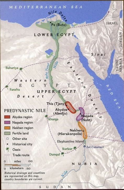
A map of prehistoric Egypt, with the locations of the most important communities marked. The part of the Nile delta north of Buto is now above sea level, but was probably underwater back then.
The Merimde had an advantage in their location next to Asia. It now appears that people and trade goods traveled between Egypt and the Middle East at a very early date--as early as 3000 B.C., if not sooner. The trade goods entering Egypt would have arrived in the Nile delta first. In this way the Merimde settlements acquired copper and turquoise from the Sinai peninsula, making these the first places where Egyptians worked with metal. However, the Egyptians would continue to use mostly stone tools for centuries to come.
The main zone for the Badarian culture is a thirty-kilometer stretch of the Nile, around the modern Egyptian city of Asyut; here forty archaeological sites and six hundred graves have been found. We have not yet identified where the Badarians came from; it has been suggested they came from the south, the western desert, or a combination of places. With the Badarians, farming and herding replaced hunting as the chief ways to obtain food. On the edge of the desert, they learned to make buildings or storage pits, to hold grain for times when food was in short supply. We believe the first farmers also domesticated the animals that would become the livestock on farms later on, especially cattle. No doubt the first Egyptian farmers tried crops that had already been grown in other parts of Africa, like sorghum, but the most important crops they planted -- wheat, barley, lentils and grapes -- came from the Middle East originally. Whoever brought the seeds for those crops from the Middle East had to pass through Lower Egypt first, but Lower Egypt was too swampy to grow them in prehistoric times. Only after irrigation tamed the Nile delta, would it become the fertile place for agriculture that it is now. Therefore Lower Egyptians (the Merimde) continued to get most of their food by hunting and fishing.
For the Badarians, artistic and technical skills improved, too. From Badarian sites we have found black-topped pottery, and crafted stone tools like axes, scrapers, bifacial sickles, and concave-base arrowheads. In addition, there are pots, vases, ivory and turquoise from the lands surrounding Egypt, showing that the Badarians conducted extensive trade. Now the dead were buried in cemeteries, wrapped in reed mats or animal skins, and positioned with their heads pointing south and looking west, an early sign of future Egyptian traditions that called the land west of the Nile the "land of the dead." Dogs were buried with them, showing they had an important place in society. Here we also see the beginning of social stratification, as some individuals were buried with more grave goods than others, and in a separate section of the cemeteries.
The next culture in Upper Egypt is sometimes called the Amratian culture. It started as a parallel culture to the Badarian, but eventually superimposed itself on the other, and finally replaced it. The most important Amratian site is Naqada, where the city of Nubt would later be built, so this culture is also called Naqada I; it depends on who you're reading. With the Amratians/Naqada I we see further advances in agriculture, pottery, and most important of all, social organization. For example, the former tribal communities are now organized into villages, with a tribal chieftain or leader in charge of each one. Each village had its own animal deity, which was represented with a clan ensign. These ensigns would be mounted on poles and carried, in processions or to battles. From these villages came the different Egyptian nomes - the city-states or provinces of a united Egypt later on.
In other developments, we have found clay model houses in the graves, showing us they had learned to build structures from mud bricks. The dead were also buried with food, weapons, amulets, ornaments, decorated vases and statuettes. The statuettes were meant to keep the deceased person company in the afterlife; these were the forerunners of the ushabti figurines that would often go into Egyptian tombs. Moreover, it looks like the first attempts to irrigate the land on the banks of the Nile were tried at this time. And the growing of flax suggests that the Egyptians had learned to weave linen by now. Also, Upper Egypt was trading regularly with Lower Egypt and Nubia; trade with the oases and the Sinai probably took place as well. Finally, the Egyptians started making stone palettes to grind cosmetics. At this stage the palettes were usually plain, without much decoration; they would use their best artistic skills to decorate these household items later on.
A predynastic burial, in the Naqada I style.
(From the Oriental Institute, Chicago.)
Meanwhile, another culture that we call El Omari (named after the discoverer, Amin el-Omari) appeared in Lower Egypt, in the vicinity of modern Cairo. So far little has been found besides storage pits, post holes, and refuse pits. It appears the people lived in wattle-and-daub huts. The pottery is undecorated, and they used stone tools exclusively. Burials were also simpler; for grave goods, the deceased might get only one pot. We should probably consider the El Omari culture a transitional stage between the Merimde and the next Lower Egyptian culture, the Maadi.
Some history texts declare that the true beginning of the Egyptian state came with the Amratians. Myself, I don't agree. Up to this point, the development of the cultures in Egypt followed a similar path to the cultures in the other "cradles of civilization," like Mesopotamia and China. My opinion is that Egypt really got started with the next culture to come after Naqada I, because in this period, some of the key elements of Egyptian civilization make their appearance. To give one example, with the next culture, the local totems become recognizable as future gods in Egyptian mythology, like Horus, Hathor and Ra. This culture is called both Naqada II and the Gerzean culture, named after Girzeh (also Girza or Jizrah), a prehistoric cemetery between the Nile and the Faiyum oasis. Besides Girzeh, the main sites for this culture are at Naqada/Nubt and Nekhen, a town far up the Nile (later called Hierakonpolis). Abydos, a community 80 miles downstream from Naqada, was another important site.
The Gerzean culture is characterized by pottery painted with dark red figures. The villages from the Amratian age grew into towns, and the residents of those towns mastered the techniques of irrigation. Metallurgy techniques improved as well, allowing them to make copper tools and use them alongside stone tools. We call this level of technology the chalcolithic age. But while communities in the Middle East were already mixing copper with arsenic or tin to make bronze, Egypt would stay chalcolithic for quite a while; even the pyramids would be built using a combination of copper and stone tools. Not until the Middle Kingdom, after 2000 B.C., would Egypt fully enter the bronze age.
We already mentioned that ideas and trade goods traveled between Egypt and the Middle East at a very early date--as early as 3000 B.C., if not sooner. Is it possible that people migrated along those trade routes as well, and stayed when they arrived? Sir Flinders Petrie thought so. When Petrie excavated the predynastic cemetery of Nubt, he noticed that the graves had two different styles of burial, depending on whether they came from the Naqada I or Naqada II cultures. Whereas the Naqada I people were buried in a fetal position and covered with palm branches (a style the poorest Egyptians would practice for centuries to come), the Naqada II graves were lined with bricks and covered with palm logs. Moreover, instead of keeping the body in one piece, the Naqada II culture dismembered the dead before burial, and knife and teeth marks on the bones suggest that ritual cannibalism was practiced. Finally, the pottery styles in the two types of graves were very different, and even the skulls were of different shapes, leading Petrie to conclude that the ruling classes of the Naqada I and Naqada II peoples were not the same at all.(8)
To explain all this, Petrie proposed the "Dynastic Race theory" to explain the changes. According to this, a group of outsiders invaded and conquered Nubt; artifacts at Nekhen tell us that Nekhen was a second base for the same people. Petrie also called these elite foreigners the "Falcon Tribe," because the falcon was one of their symbols from the start, and soon Nekhen became the main cult center for Horus, the Egyptian falcon god. Nubt is where the Nile meets the Wadi Hammamat, a sixty-mile-long valley at the narrowest point between the Nile and the Red Sea, so he went on to suggest that the newcomers were Mesopotamians, who sailed around Arabia, entered the Red Sea, and marched through the Wadi Hammamat to get here. Later on one of their descendants would conquer the rest of Egypt and crown himself as the first pharaoh.(9)
The "Dynastic Race" theory went out of fashion in the mid-twentieth century, because it was too politically incorrect for a time when the world's most advanced nations were shedding their colonies. Then in 1998 it was revived by another British Egyptologist, David Rohl, who felt that the story of newcomers in Egypt could be told correctly if the imperialist elements were left out. Besides the previously mentioned evidence, Rohl cited the following:
- Petroglyphs in the eastern desert, showing high-prowed boats and pear-shaped maces; the Sumerians had both items first.
- Mud bricks, Mesopotamian-style pottery, and tombs built with Mesopotamian-style niched walls.
- The presence of lapis lazuli, a purple semi-precious stone from Afghanistan, in the Naqada II graves. It would not appear in Egyptian graves again until late in the Old Kingdom, about six centuries later.
- Pear-shaped maces in the graves of Naqada II warriors. This proved to be a more destructive weapon than the small bows and disk-shaped maces used previously. In fact, it was so effective that later on, the pharaohs would routinely have pictures done showing them using pear-shaped maces on their enemies.
- The first examples of writing, the famous Egyptian hieroglyphics, which we see near the end of the Naqada II period, on pottery and the previously mentioned palettes. A casual comparison of hieroglyphics and other ancient scripts, like cuneiform, show they have nothing in common, but the fact that hieroglyphics first appeared at this time suggests that the Egyptians got the idea for writing from somebody else. So far we have not found evidence of a long period of trial and error, as was the case when cuneiform was developed. At this stage, hieroglyphics were written by themselves, or in groups of two characters; the early scribes have not yet learned how to put enough of them together to form sentences.
For the author of this work, the most compelling piece of evidence is a stone knife with an ivory handle, found a century ago at Gebel el-Arak. On one side of the knife handle is a carving showing a battle between two groups, with the tell-tale high-prowed boats nearby. On the other side is a man with a full beard, wearing a woolen robe and a Sumerian-style hat, wrestling with two lions. This pose looks very much like how the Mesopotamians portrayed heroes like Gilgamesh, to the point that one is tempted to look at the handle and say, "This is Nimrod!" Mesopotamian-style cylinder seals have also turned up at Naqada II sites.
If Egypt's first rulers were foreigners, they did not remain distinct from their subjects for very long. Perhaps we should see them as a catalyst, like the Normans in England and the Varangians in Russia; after speeding up the development of the land they took over, they were absorbed into the masses. By the end of the second dynasty of pharaohs, the only way one could identify members of the "Dynastic Race" was by whether or not they belonged to Iry-Pat (hereditary nobility) families.
While the Naqada I and Naqada II cultures dominated Upper Egypt, Lower Egypt had the Maadi culture, which is best known from two sites: Buto in the northern delta, and Maadi, a suburb of modern Cairo. We don't have too many Maadi artifacts, because land development over the past century has destroyed much of the sites. What we do know is that during the Maadi period, copper tools became common, while the pottery continued to have few decorations. Pottery in the styles of Upper Egypt and the Holy Land has also been found, indicating that the Maadi traded a lot with their neighbors. As with the Omari culture, the people of the Maadi culture lived in small huts, partly dug into the ground, and the dead were buried in cemeteries, but with few burial goods. The Maadi culture was eventually replaced by the Naqada III culture (see footnote #10); it is not clear whether this happened by conquest or infiltration.
The Naqada II period was also the time when Egypt's city-states were united, to form larger kingdoms. We already mentioned that battle scenes were a subject in the art; we also see the first symbols of a pharaoh's authority. One of them was the ruins of the oldest known palace, at Nekhen. The main feature of this palace that has been identified is a large courtyard, which appears to have doubled as a place for slaughtering and butchering cattle.
Tradition holds that before the first pharaoh took charge, Egypt was divided into two states: Lower (northern) Egypt in the Nile delta, with its capital at Buto, and Upper (southern) Egypt along the river's main channel. Presumably this was an intermediate step between the city-states mentioned above and the united Egypt we will see in the next chapter. There is some confusion as to whether Abydos or Hierakonpolis was the capital of Upper Egypt at this stage; the author believes that Abydos, or the neighboring town of Thinis, was the capital, even if the ruling family came from farther south, simply because it would make sense to put the capital as far north as possible, if all the action was in the north. Unfortunately, the relatively wet climate of the delta doesn't preserve artifacts as well as Upper Egypt; however, that doesn't rule out the possibility that a united Lower Egyptian state once existed.
Apparently the crucial step in the unification process came shortly after 3000 B.C., with the merging of three city-states in the south: Abydos, Nubt (Naqada) and Nekhen (Hierakonpolis). How this was done is unknown, but the myth of Osiris, Horus and Set (see the next chapter) may be an allegorical tale of the unification process; it appears to the author that Nubt first conquered Abydos, only to be replaced by Hierakonpolis later on. So far no scenes have been found depicting fighting between Nubt and Hierakonpolis, so it is possible they got together by forming an alliance between the two cities, or a trading cartel like today's European Union, and over time they merged into one state; some marriages between the families ruling both cities would be appropriate, too. However unification happened, the result was a single state 200 miles long, which wielded power that no other city-state could match.
We also think we know the name of the king who presided over the unification of Upper Egypt: Iry-Hor. Egyptologists don't agree on what the name means, but the most popular interpretation is "Voice of Horus," because the two hieroglyphs used to write his name were a falcon, representing the god Horus, and an oval, which is thought to represent a mouth. Iry-Hor's name appears in the oldest tomb found at Abydos (excavated in 1902), but Egyptologists did not accept him as a real king until his name turned up as part of an inscription in the Sinai peninsula, in 2012. We have no dates for when he lived, except that he probably lived more than 5,000 years ago; in fact, it's hard to know anything about someone from that far back. Still, he has now been declared the first king, and possibly the first person, whose name has been written down anywhere.
![]()
The Real Scorpion King(s)
After Iry-Hor, we know the names of a few more kings, from both Upper and Lower Egypt, but all we have from them are just that -- names. During this time, a new hieroglyph was added to inscriptions, which we call a serekh (facade). Apparently the first scribes got the idea that the name of a king or queen should stand out from all other words. To do this, they drew a picture of a rectangular structure, and we think this is supposed to represent a palace. On top of the serekh, they usually put the falcon that represents the god Horus; by now the falcon had become a symbol of kingship. At first the name of the royal person was put next to the serekh, but before long they started putting the name inside the serekh, thereby isolating it from other words completely.
Next came an Upper Egyptian ruler who left a slightly more substantial record of his achievements. Like Iry-Hor, his name was written with two hieroglyphs, this time a falcon and a scorpion, so we call him either King Scorpion or the Scorpion King. To stay consistent with the way we organize Egyptian history, some scholars refer to the Scorpion King and the monarchs before him as "Dynasty 0."
If you were born before the twenty-first century began, you may remember two movies where Dwayne "The Rock" Johnson, an actor and former wrestler, played the Scorpion King:
"The Mummy Returns" (2001), and "The Scorpion King" (2002). You won't learn any history from them; just watch them for their entertainment value. Those movies were a place where "The Rock" practiced his acting skills; he has been a better actor since then, anyway. The real Scorpion King may not have even looked like Mr. Johnson. If rock art can be trusted, the Scorpion King may have been a thin man with a beard (see below).
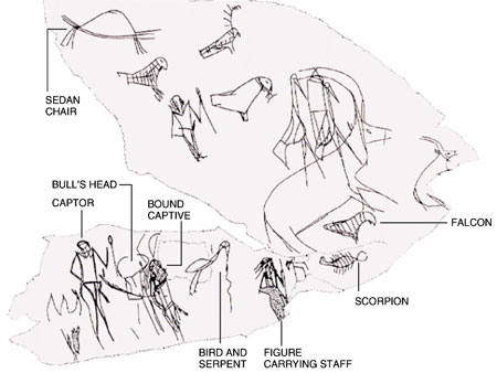
Is this the world's oldest historical inscription? Found in the western desert in 1995, this petroglyph appears to show a predynastic king returning from a successful military expedition, with an enemy chief as a prisoner. Note the picture of a scorpion next to a picture of a falcon--that's how we identify the one carrying the staff. Another example of desert graffiti shows a scorpion capturing an enemy; that was found at the Nile's Second Cataract, near the present-day border between Egypt and Sudan.
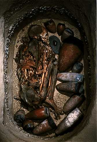
First, I should mention that because he lived so long ago, we know very little about this king. Originally he was just assumed to be the immediate predecessor of Narmer, the conqueror who united Egypt at last. Now scholars are suggesting there was not one, but two or even three Scorpion Kings, but they can't say when they lived, or how they are related to each other. And a tomb bearing the Scorpion King's hieroglyphs was found at Abydos in 1989, but if there was more than one king by that name, we don't know if the one buried there was Scorpion I, II, or III.
Most of the artifacts we have from the Scorpion King show him either fighting his enemies, or with captives. One opponent had a hieroglyph of a bull's head for his name, so we call him "Bull's Head" or "Taurus," and he appears to have lived in the vicinity of Nubt. However, because there wasn't a serekh next to his name, not everyone believes Taurus was an enemy king; perhaps he was a rebel. Another opponent wrote his name as two falcons perched on a serekh; we call him "Double Falcon," and we think he ruled the eastern half of the Nile delta. Pictures like these have been found as far south as the Second Cataract of the Nile, near the present-day border between Egypt and Sudan. And in the Abydos tomb were ivory tags bearing the names of places; either these were the cities/countries of the enemies he fought, places he ruled, or places he traded with. But the most important artifact shows the king doing a peaceful activity. This is a stone, pear-shaped mace head, and carved on it is an image of the king standing in a field, holding a hoe. Our guess is that he was performing a ritual, to make the gods bless Egypt with good crops. Also, this is the first time we see anyone dressed like a pharaoh. For instance, the Scorpion king is wearing a crown shaped like a bowling pin, which we know will be the white crown of Upper Egypt in later generations (see the next chapter).
Finally, for what it's worth, we know that the Scorpion King loved wine. The Abydos tomb contained hundreds of jars with a yellow residue, and scientists have identified the residue as coming from wine, with some resins and herbs added. We estimate that the jars could have held 4,500 liters, if they were filled all the way; the king must have been expecting to have a huge party in the afterlife!
Now we have come to the point where writing develops enough for history to begin in Egypt. On that note, we will break off our narrative on Egypt here, and continue it in the next chapter.(10)
![]()
In the Rest of Africa
West of Egypt, the first fully developed civilization was that of the Carthaginians, centered in modern-day Tunisia. Here we have even less to go on when it comes to artifacts showing this area's development (presumably because the Romans did a very thorough job of destruction when they finished off Carthage in 146 B.C.), but we know who was responsible; Greek and Roman records identify the founders as Phoenicians coming from Tyre, the greatest city of ancient Lebanon. The complete story of the Egyptians, Nubians and Carthaginians will be covered in detail in the next three chapters of this work.
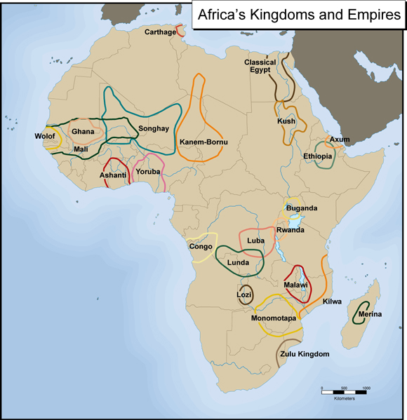
Here are the most important kingdoms that existed in Africa before the Europeans took over, in the late nineteenth century A.D. The purpose of the map is to show where each kingdom was; keep in mind that several were too small to appear on a map of this scale, like Benin. Also, the core territory of each is shown, but in some cases these borders do not reflect the kingdom's size at its peak. For example, while you can see the Merina kingdom was based in the heart of Madagascar, the borders are the ones it had around 1800 A.D.; afterwards it conquered most of the island. In the north, Egypt ruled Nubia (the area occupied by Kush) and the nearest parts of Asia more than once, while Carthage dominated the western Mediterranean, the European as well as the African shore, during its best years between 500 and 200 B.C.
This is the End of Chapter 1.
FOOTNOTES
1. National Geographic devoted its entire September 2005 issue to Africa, but even that magazine, famous for its photography, could not find a photo that was appropriate for all of Africa. In the end they chose to put a satellite photo of the continent on the cover, under a title that said, "Africa: Whatever you thought, think again."
2. Black Africans learned to cultivate eight grains, four root vegetables, and nearly forty other plants, including cucumbers, melons, okra and onions.
We know from Old Kingdom-style hieroglyphics on rocks in Egypt's western desert, and from pottery at various sites, that caravan routes between Egypt and Chad were in regular use as early as the IV dynasty (2400 B.C.?), and they may have been in use even in predynastic times.
3. Evolutionists will assert that Africans are diverse because people have been living and breeding for longer in Africa than they have anywhere else. For my opinions on the origins of mankind, read Chapter 5 of The Genesis Chronicles: A Proposed History of the Morning of the World.
4. The popular conception that the Sahara contains nothing but sand is incorrect. A quarter of it is indeed a sea of dunes, called ergs, but the rest is gravel beds (regs), plains of boulders (hammadas), oases, and mountains. The tallest mountains, the Tibesti in northern Chad, are more than 11,000 feet high. These mountains contain a few cypress and olive trees--plants which are the companions of poor soil, never die of old age, and are the last living evidence of what the Sahara used to be like.
The most desolate part of the modern Sahara is the T�n�r� region, which occupies northeastern Niger and part of western Chad. Tuareg nomads call the T�n�r� "a desert within a desert." The world's loneliest tree, the "Tree of T�n�r�," was this desert's last tree and the main landmark in the region, until it was reportedly knocked down by a drunken Libyan truck driver in 1973. But even the T�n�r� once was home to lively human communities. At a site in Niger called Gobero, some paleontologists searching for dinosaur bones found 200 graves, which they have identified as belonging to the Kiffians and Tenerians, two prehistoric cultures that existed in a wetter Sahara.
5. The ancients saw Africa as three countries: Egypt, Libya and Ethiopia. However, only with Egypt did they mean the same country that we call by that name today. "Libya" meant the rest of North Africa, from present-day Libya to Morocco, while "Ethiopia" meant all of black sub-Saharan Africa. Ethiopia's name comes from Aethiops, meaning "burnt skin," from the Greek myth which asserted that once the sun came too close to Africa, and burned most of the inhabitants black. Thus, when the Bible refers to somebody as an "Ethiopian" or "Cushite," it probably means the person in question was black. Sometimes the name Ethiopia is interchanged with Nubia, meaning the part of the Nile valley between Khartoum and the Aswan Dam; don't confuse it with modern Ethiopia, which was called Abyssinia before World War II.
6. The reason why the land between the Mediterranean and the Atlas Mts. is near-desert today is because it has been so misused over the past 2,000 years. Forests were cleared, because of the need for both farmland and wood, and bad farming practices ruined the fertility of the soil, while much of the wildlife was slaughtered, hunted for sport or taken to arenas like the Colosseum in Rome for entertainment. Fields lost their protective ground cover to overgrazing, especially from sheep and goats, which do a more thorough job on the roots of plants than cattle. In the fourth century B.C., Plato described the ecological damage done to Greece with these words: "What now remains, compared with what existed, is like the skeleton of a sick man, all the fat and soft earth wasted away and only the bare framework of the land being left." By the time the Romans were finished, the same could be said for the whole Mediterranean basin.
7. Georg Wilhelm Hegel, the famous philosopher, wrote in 1854 that "Africa is not an historical continent; it shows neither change nor development, and whatever may have happened there belongs to the world of Asia and of Europe." As recently as 1961 Hugh Trevor Roper, a professor of history at Oxford, expressed the same prejudice: "At present there is no African history; there is only the history of the Europeans in Africa. The rest is darkness."
8. The people of the Naqada II culture also made regular offerings of bread and beer to the dead. This isn't really a surprise, since they were now growing plenty of grain. However, at least one Egyptologist has suggested that enough bread and beer was made for the offerings, to rival what was made for the living. Of course, someone could have consumed the goods after the religious services took place, before they had time to spoil. These customs are a foreshadowing of the practice of building mortuary temples near the tombs of the pharaohs, where the priests would make offerings to the dead pharaoh's spirit (we'll see that in the next chapter).
9. To see more on what I wrote about the Dynastic Race theory, check out Chapter 12 of The Genesis Chronicles.
While excavating the cemetery used by the upper class of Nekhen, archaeologists found the graves of more than a hundred animals: dogs, hippos, hartebeest, cows, elephants, baboons, and leopards. Later on, when the Egyptians worshipped animals that they believe represented the gods, they mummified millions of critters, but usually they buried only one species in any given cemetery. Moreover, most of these animals are not the kind that make good pets, so it has been proposed that before 3000 B.C., Nekhen/Hierakonpolis had the oldest known zoo. The tomb of the zoo's owner was discovered in 2014. Presumably he was the ruler of the city, but somebody didn't like him; his body and the tomb's structure were burned, and then in the I dynasty an effort was made to restore the tomb. From this we know that even before Egypt was united, there must have been power struggles over who would rule the cities.
10. In the author's opinion, Egyptian culture was still in a formative stage, not fully developed until the beginning of the Old Kingdom (around 2500 B.C.). Sometimes the last stage of development in Egyptian culture is called Naqada III, to show the continuation from Naqada II. Naqada III covers the period we call the First Dynasty, and maybe the Second Dynasty as well.
Support this site!
![]()
PAGE NAVIGATOR
A History of Africa
|
Other History Papers |
Beyond History
|